Old Maps of Umnak, Alaska
Explore 3 old maps of Umnak, spanning from 1951 to today. These high-resolution historic maps reveal how streets, neighborhoods, landmarks, and natural features evolved over time — perfect for genealogy, metal detecting, research, and local history exploration.
What you can do with these maps:
- See how Umnak changed over time: Compare historical maps to modern-day views to trace roads, homesites, rail lines & more.
- View detailed metadata: Each map includes creators, publishers, year, scale, and archive source.
- Overlay maps with satellite & LiDAR: Visualize the past alongside modern tools to explore terrain & human change.
- Trusted historical sources: Maps sourced from the USGS, Library of Congress, and other archives.
- Access maps your way: View online, download high-res files, or order prints for personal or research use.
Start exploring old maps of Umnak to uncover forgotten places, hidden landmarks, and the deep history beneath your feet.
Umnak, AK maps
(3)- 1951 Map of Umnak, 1952 Print
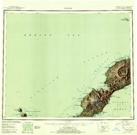 1951 Umnak1952 Print · USGSThe Aleutian landscape in the early fifties reveals a remote volcanic terrain at the edge of the Bering Sea. Researchers can trace landforms like Mt Vsevidof, the coastal features of Inanudak Bay, and isolated outposts such as Bogoslof Island.8 unique versions available
 - 1958 Map of Umnak
 1958 Umnak1958 Print · USGSUmnak Island and the eastern Aleutians are documented here in the mid-fifties, showing a landscape defined by volcanic activity and Cold War military installations. Researchers can trace the Air Force Base and island landmarks like Okmok Caldera and Mt Vsevidof.
 - 2021 Map of Umnak B-1 SW, 2021 Print
 2021 Umnak B-1 SW2021 Print · USGSUmnak Island’s remote interior is documented in this recent survey, capturing the island's steep volcanic topography as it reaches the sea. Researchers and hikers can trace the natural corridors through Hourglass Pass and Bottleneck Pass down to the Pacific Ocean.
End of results
Showing maps 1-3 of 3
Frequently asked questions
- What are the different types of historical maps available for Umnak?
- What is the oldest map of Umnak?
- Where can I purchase historical maps of Umnak for my home or office?
- Where can I download high-res historical maps of Umnak?
- Are there historical topographic maps available for Umnak?
- Is there historical aerial imagery available for Umnak?
- Where are historical maps of Umnak sourced from?