1980s Maps of Unalaska, Alaska
Explore 2 historic maps of Unalaska from the 1980s. These maps offer a rare glimpse into what life looked like during the 1980s — showing old roads, neighborhoods, homes, and landmarks that have changed or disappeared over time.
Whether you're researching your family's past, planning a metal detecting trip, or studying how Unalaska's landscape evolved across the 1980s, these high-resolution maps are a powerful tool for exploring the history of this region.
- Focus on a specific era: All maps on this page are from the 1980s, giving you a focused view of this time period.
- See what’s changed: Compare century-old streets, trails, and buildings to today's modern landscape using overlays and satellite layers.
- Research with precision: Use these maps for genealogy, historical research, land use analysis, or educational projects.
- View, download, or print: Maps are fully viewable online in high resolution, and can be downloaded or printed for your own records.
Start exploring Unalaska's history through authentic maps from the 1980s. This is your window into the past.
Unalaska, AK maps
(2)- 1989 Map of Unalaska C-3
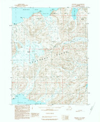 1989 Unalaska C-31989 Print · USGSUnalaska Island's volcanic interior is documented in the late 1980s, showcasing the high peaks and coastal bights of the Aleutian chain. Researchers can trace the remote Landing Strip at Driftwood Bay or locate landmarks like Makushin Volcano and McLees Lake.
 - 1989 Map of Unalaska D-2
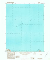 1989 Unalaska D-21989 Print · USGSThe northern approaches to the Aleutians are captured in the late 1980s, documenting the vital maritime gateway of Unalaska Bay. Researchers can trace coastal landmarks like Priest Rock Light, Cape Kalekta, and The Dry Dock.
End of results
Showing maps 1-2 of 2
Top neighborhoods of Unalaska
Frequently asked questions
- What are the different types of historical maps available for Unalaska?
- What is the oldest map of Unalaska?
- Where can I purchase historical maps of Unalaska for my home or office?
- Where can I download high-res historical maps of Unalaska?
- Are there historical topographic maps available for Unalaska?
- Is there historical aerial imagery available for Unalaska?
- Where are historical maps of Unalaska sourced from?