Old Maps of Old Valdez, Valdez for Academic Research
Study the evolution of Old Valdez with 7 high-resolution historic maps. Whether you're teaching, researching, or modeling changes in land use, these maps provide essential visual documentation of urban, environmental, and geographic change.
- Analyze long-term change: Track patterns in development, transportation, and natural features.
- Ideal for environmental or urban studies: Support academic projects with primary historical map data.
- Use in the classroom or lab: Educators and researchers rely on these maps to bring historical context to life.
These maps are a powerful tool for teaching, research, and visualizing how Old Valdez has changed over the decades.
Old Valdez, Valdez maps
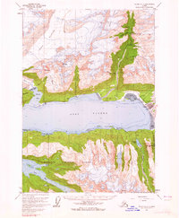
(7)- 1952 Map of Valdez
 1952 Valdez1952 Print · USGSCoastal Alaska met the interior via mountain passes and river valleys during the mid-century, before the 1964 earthquake altered the shoreline. Trace mining history at Midas Camp and Cliff Mine, or locate remote stations like Tiekel Cache and Copper Center.4 unique versions available
 - 1960 Map of Valdez A-7, 1965 Print
 1960 Valdez A-71965 Print · USGSThe port of Valdez and its surrounding mining districts are captured here in the early sixties, prior to the transformative 1964 earthquake. Researchers can trace the town's original layout, the Richardson Highway, and numerous lode sites like the Midas Mine and Cliff Mine.3 unique versions available
 - 1960 Map of Valdez, 1967 Print
 1960 Valdez1967 Print · USGSCoastal and interior Alaska meet in this mid-century study of the Chugach Mountains and the copper-rich river valleys. Trace the legacy of early industry along the Copper River and Northwestern Railroad and locate settlements like Copper Center, Chitina, and Fort Liscum.6 unique versions available
 - 1983 Map of Valdez A-7 SE
 1983 Valdez A-7 SE1983 Print · USGSCoastal Alaska in the early eighties shows the intersection of the energy industry and a relocated community. Trace the massive Valdez Marine Terminal, the former Old Valdez (Site), and remote landmarks like the Midas Mine.
 - 1996 Map of Valdez A-7, 1999 Print
 1996 Valdez A-71999 Print · USGSThe Port Valdez region underwent significant transformation in the late twentieth century as it became the terminus for the Trans-Alaska Pipeline. Modern infrastructure like the Oil Terminal stands alongside historic sites such as Old Valdez, the Hercules Mine, and Fort Liscum (Site).
 - 2016 Map of Valdez A-7 SE, 2016 Print
 2016 Valdez A-7 SE2016 Print · USGSCovers Old Valdez, including Valdez, Unorganized Borough, and other nearby areas
 - 2023 Map of Valdez A-7 SE, 2023 Print
 2023 Valdez A-7 SE2023 Print · USGSThe Port of Valdez area is shown in this recent survey, capturing the industrial and natural character of the Sound. Researchers can trace the Alaska Pipeline and compare the layout of Valdez with the original site of Old Valdez.
End of results
Showing maps 1-7 of 7
Top cities near Old Valdez
Frequently asked questions
- What are the different types of historical maps available for Old Valdez?
- What is the oldest map of Old Valdez?
- Where can I purchase historical maps of Old Valdez for my home or office?
- Where can I download high-res historical maps of Old Valdez?
- Are there historical topographic maps available for Old Valdez?
- Is there historical aerial imagery available for Old Valdez?
- Where are historical maps of Old Valdez sourced from?