Old Maps of Whitefish Lake, Alaska for Genealogy
Trace your family roots with 5 historic maps of Whitefish Lake. These high-res maps reveal old neighborhoods, homesites, landmarks, and streets — helping you uncover where your ancestors lived and how the area evolved over time.
- Explore historic neighborhoods: Identify where your relatives may have lived in the 1800s or 1900s.
- Compare maps over time: Trace the changes in streets, buildings, and landmarks for multi-generational research.
- Perfect for genealogy & ancestry research: Used by family historians and researchers to map out lineage and migration.
These maps are an incredible resource for exploring your personal connection to Whitefish Lake's past.
Whitefish Lake, AK maps
(5)- 1946 Map of Lake Clark, 1954 Print
 1946 Lake Clark1954 Print · USGSInterior Alaska during the mid-forties and early fifties reveals a remote landscape of glacial lakes and mountain peaks. You can trace early settlements at Nondalton, find the Old Village trail network, and locate the Tanalian Point Landing Field near the shores of Lake Clark.2 unique versions available
 - 1951 Map of Lake Clark
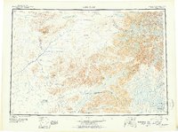 1951 Lake Clark1951 Print · USGSThe Lake Clark region of the Alaskan interior was a remote frontier in the early 1950s, defined by high peaks and sprawling river systems. Researchers can trace historic travel routes like the Native Trail and locate isolated settlements at Old Village or Nondalton.2 unique versions available
 - 1954 Map of Lake Clark D-6, 1968 Print
 1954 Lake Clark D-61968 Print · USGSSouthwestern Alaska in the mid-fifties remained an expansive wilderness where water and elevation defined the only landmarks. Trace the pristine courses of the Mulchatna River and Hohotitna River past remote peaks like Dhani and Hono.2 unique versions available
 - 1958 Map of Lake Clark, 1967 Print
 1958 Lake Clark1967 Print · USGSLake Clark and the surrounding wilderness are captured during the 1950s as a remote frontier of rivers and volcanic peaks. Researchers can locate early outposts like Port Alsworth and trace the paths of the Summit Trail or the waters of Kontrashibuna Lake.4 unique versions available
 - 2019 Map of Lake Clark D-6 NE, 2019 Print
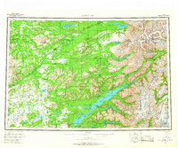
 2019 Lake Clark D-6 NE2019 Print · USGSThe wilderness of southwest Alaska is shown here in the late 2010s, focusing on the aquatic landscape of the Lake and Peninsula Borough. Researchers can trace the winding Hoholitna River and the complex wetlands surrounding Whitefish Lake.
End of results
Showing maps 1-5 of 5
Frequently asked questions
- What are the different types of historical maps available for Whitefish Lake?
- What is the oldest map of Whitefish Lake?
- Where can I purchase historical maps of Whitefish Lake for my home or office?
- Where can I download high-res historical maps of Whitefish Lake?
- Are there historical topographic maps available for Whitefish Lake?
- Is there historical aerial imagery available for Whitefish Lake?
- Where are historical maps of Whitefish Lake sourced from?