
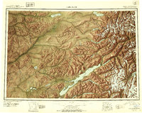
1946 Map of Lake Clark
USGS Topo · Published 1954About this map
Lake Clark and its surrounding river systems define this interior Alaskan landscape, as documented in this mid-century reconnaissance. The glacial waters of Little Lake Clark and Kontrashibuna Lake are framed by massive peaks like Iliamna Volcano and Mt Nick. Human presence in this era was concentrated at the settlement of Nondalton and the Old Village near the Telaquana River, with a Native Trail connecting the remote highlands. The map highlights early aviation infrastructure essential to the region, notably the Tanalian Point Landing Field at Tanalian Point. This survey captures a moment when the Mulchatna River and Chilikadrotna River headwaters remained largely unpopulated, divided only by the administrative line of the Fourth and Third Judicial Divisions.
Find a feature on this map
53 named features on this map. Tap any name to fly to it.
Don’t see what you’re looking for? This feature index may not catch every label — zoom into the map to look around manually.
Map Details
Editions of this 1946 Lake Clark Map
2 editions found
Other maps of this area

1944 · Kenai
USGS Topo · 1:250,000

1949 · Tyonek
USGS Topo · 1:250,000

1950 · Kenai
USGS Topo · 1:250,000

1950 · Sleetmute
USGS Topo · 1:250,000

1950 · Taylor Mountains
USGS Topo · 1:250,000

1951 · Lake Clark
USGS Topo · 1:250,000

1951 · Taylor Mountains
USGS Topo · 1:250,000

1951 · Tyonek
USGS Topo · 1:250,000

1951 · Lime Hills
USGS Topo · 1:250,000

1951 · Dillingham
USGS Topo · 1:250,000