Old Maps of Willow Creek, Alaska for Hiking & Exploration
Hike through history with 5 historic maps of Willow Creek. Explore old trails, ghost towns, and forgotten backroads — perfect for outdoor adventurers and local explorers.
- Rediscover forgotten places: Map out old mining camps, roads, and footpaths that no longer exist on modern maps.
- Layer with modern tools: Combine with LiDAR or satellite views to plan hikes through historical terrain.
- Made for exploration: Popular among hikers, overlanders, and local history lovers.
Use these maps to find adventure and explore the hidden past of Willow Creek.
Willow Creek, AK maps
(5)- 1947 Map of Russian Mission, 1957 Print
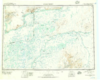 1947 Russian Mission1957 Print · USGSSouthwest Alaska in the late 1940s is mapped here as a vast network of river settlements and mountain outposts. Researchers can trace historic river life and early aviation at Russian Mission, Kako Air Field, and Crow Village.2 unique versions available
 - 1950 Map of Russian Mission
 1950 Russian Mission1950 Print · USGSThe Yukon-Kuskokwim Delta region comes alive in the early post-war era, showing the river-bound lifeways of the Alaskan interior. Local historians and genealogists can trace remote outposts like Russian Mission, Dogfish Village, and Nyac, or locate family sites like Phillips Broe.
 - 1952 Map of Russian Mission D-8, 1962 Print
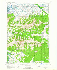 1952 Russian Mission D-81962 Print · USGSRemote Alaskan wilderness in the early fifties shows a landscape of mining claims and winter transport routes near the Yukon River. Researchers can trace the Winter Trail through the lowlands or locate the Willow Creek Mine near Mount Okumiak.2 unique versions available
 - 1980 Map of Russian Mission
 1980 Russian Mission1980 Print · USGSThe Yukon and Kuskokwim river basins are detailed here during the late twentieth century, showing a network of remote villages and seasonal camps. Researchers can trace traditional travel routes and settlements like Russian Mission, Chuathbaluk, and the historic Portage Trail.3 unique versions available
 - 2017 Map of Russian Mission D-8 SW, 2017 Print
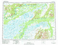
 2017 Russian Mission D-8 SW2017 Print · USGSKusilvak, Alaska, is captured here in the early twenty-first century, showcasing a landscape of high summits and intricate creek systems. Researchers can trace the drainages of First Chance Cr and Spruce Cr or locate the peak of Mt Okumiak.
End of results
Showing maps 1-5 of 5
Top cities near Willow Creek
Frequently asked questions
- What are the different types of historical maps available for Willow Creek?
- What is the oldest map of Willow Creek?
- Where can I purchase historical maps of Willow Creek for my home or office?
- Where can I download high-res historical maps of Willow Creek?
- Are there historical topographic maps available for Willow Creek?
- Is there historical aerial imagery available for Willow Creek?
- Where are historical maps of Willow Creek sourced from?