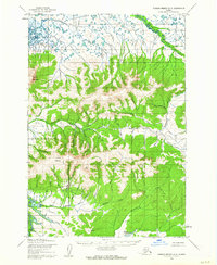
1952 Map of Russian Mission D-8
USGS Topo · Published 1962About this map
Mount Okumiak and Pitcher Mountain anchor this landscape in the Yukon-Kuskokwim Delta region during the early 1950s. The topography is defined by a dense network of drainages such as Saint Amand Creek, Edgar Creek, and Disappointment Creek that flow from the highlands toward the Yukon River. This survey captures the remote mining and transportation infrastructure of the era, notably the Willow Creek Mine and the established Winter Trail navigating the lowlands. The presence of named water bodies like Engineer Lake and numerous forks of the Kuyukutuk River suggests a terrain where seasonal water and ice dictated movement and resource extraction long before modern development altered the area's character.
Find a feature on this map
34 named features on this map. Tap any name to fly to it.
Don’t see what you’re looking for? This feature index may not catch every label — zoom into the map to look around manually.
Map Details
Editions of this 1952 Russian Mission D-8 Map
2 editions found
Other maps of this area

1947 · Russian Mission
USGS Topo · 1:250,000

1950 · Russian Mission
USGS Topo · 1:250,000

1951 · Marshall
USGS Topo · 1:250,000

1951 · Holy Cross
USGS Topo · 1:250,000

1952 · Kwiguk
USGS Topo · 1:250,000

1952 · Kwiguk A-1
USGS Topo · 1:63,360

1952 · Holy Cross A-6
USGS Topo · 1:63,360

1952 · Holy Cross
USGS Topo · 1:250,000

1952 · Russian Mission C-8
USGS Topo · 1:63,360
1952 · Russian Mission C-7
USGS Topo · 1:63,360