1900s (20th Century) Maps of Situk, Alaska
Explore 4 historic maps of Situk from the 1900s (20th Century). These maps offer a rare glimpse into what life looked like during the 1900s — showing old roads, neighborhoods, homes, and landmarks that have changed or disappeared over time.
Whether you're researching your family's past, planning a metal detecting trip, or studying how Situk's landscape evolved across the 1900s, these high-resolution maps are a powerful tool for exploring the history of this region.
- Focus on a specific era: All maps on this page are from the 1900s, giving you a focused view of this time period.
- See what’s changed: Compare century-old streets, trails, and buildings to today's modern landscape using overlays and satellite layers.
- Research with precision: Use these maps for genealogy, historical research, land use analysis, or educational projects.
- View, download, or print: Maps are fully viewable online in high resolution, and can be downloaded or printed for your own records.
Start exploring Situk's history through authentic maps from the 1900s. This is your window into the past.
Situk, AK maps
(4)- 1951 Map of Yakutat, 1952 Print
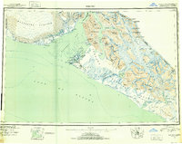 1951 Yakutat1952 Print · USGSThe coastal village of Yakutat is surveyed here in the early fifties, caught between massive ice fields and the sea. Researchers can trace the mid-century Military Airport and remote features like Harlequin Lake and the Alsek River.4 unique versions available
 - 1959 Map of Yakutat B-5, 1963 Print
 1959 Yakutat B-51963 Print · USGSThe coastal Alaskan wilderness near Yakutat is captured here in the late fifties as a landscape of glacial rivers and seasonal industry. Researchers can find traditional landmarks like Chief Situk Grave alongside the Yakutat Airport and a remote Cannery.2 unique versions available
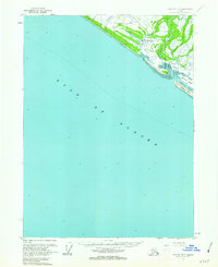
 - 1959 Map of Yakutat, 1966 Print
 1959 Yakutat1966 Print · USGSCoastal Alaska and the surrounding glaciated wilderness appear in detail during the mid-twentieth century. Researchers can trace the isolated Tractor Trail near Yakutat, find remote Cabins, and locate early industrial markers like the local Oil Well.4 unique versions available
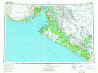
 - 1987 Map of Yakutat B-5 NE, 1988 Print
 1987 Yakutat B-5 NE1988 Print · USGSThe coastal wilderness near Yakutat in the late eighties shows a landscape of shifting sands and historic transit routes. You can trace the Old Railroad Grade through the Tongass National Forest or locate the remote settlement of Situk near the Blacksand Spit.
End of results
Showing maps 1-4 of 4
Top cities near Situk
Frequently asked questions
- What are the different types of historical maps available for Situk?
- What is the oldest map of Situk?
- Where can I purchase historical maps of Situk for my home or office?
- Where can I download high-res historical maps of Situk?
- Are there historical topographic maps available for Situk?
- Is there historical aerial imagery available for Situk?
- Where are historical maps of Situk sourced from?