Old Maps of Situk, Alaska for Metal Detecting
Plan your next treasure hunt with 6 historic maps of Situk. Find old homesites, ghost towns, trails, and gathering spots that may be lost to time — perfect for identifying promising metal detecting locations.
- Locate forgotten sites: Uncover places like long-lost settlements, abandoned rail lines, or gathering spots.
- Plan better hunts: Use map overlays combined with LiDAR or satellite views to narrow in on historically rich areas.
- Made for detectorists: Thousands of hobbyists use these maps to discover relics, coins, and hidden history.
Use these historic maps to boost your research and find new opportunities beneath the surface of Situk.
Situk, AK maps
(6)- 1951 Map of Yakutat, 1952 Print
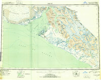 1951 Yakutat1952 Print · USGSThe coastal village of Yakutat is surveyed here in the early fifties, caught between massive ice fields and the sea. Researchers can trace the mid-century Military Airport and remote features like Harlequin Lake and the Alsek River.4 unique versions available
 - 1959 Map of Yakutat B-5, 1963 Print
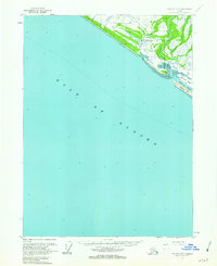 1959 Yakutat B-51963 Print · USGSThe coastal Alaskan wilderness near Yakutat is captured here in the late fifties as a landscape of glacial rivers and seasonal industry. Researchers can find traditional landmarks like Chief Situk Grave alongside the Yakutat Airport and a remote Cannery.2 unique versions available
 - 1959 Map of Yakutat, 1966 Print
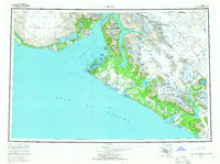 1959 Yakutat1966 Print · USGSCoastal Alaska and the surrounding glaciated wilderness appear in detail during the mid-twentieth century. Researchers can trace the isolated Tractor Trail near Yakutat, find remote Cabins, and locate early industrial markers like the local Oil Well.4 unique versions available
 - 1987 Map of Yakutat B-5 NE, 1988 Print
 1987 Yakutat B-5 NE1988 Print · USGSThe coastal wilderness near Yakutat in the late eighties shows a landscape of shifting sands and historic transit routes. You can trace the Old Railroad Grade through the Tongass National Forest or locate the remote settlement of Situk near the Blacksand Spit.
 - 2017 Map of Yakutat B-5 NE, 2017 Print
 2017 Yakutat B-5 NE2017 Print · USGSCovers Situk, including Yakutat, United States, and other nearby areas
 - 2021 Map of Yakutat B-5 NE, 2021 Print
 2021 Yakutat B-5 NE2021 Print · USGSThe Gulf of Alaska coast near Yakutat comes into focus in this recent survey of the Tongass National Forest. Local historians can trace indigenous landmarks like Chief Situk Grave and the geography of the Situk River and Blacksand Island.
End of results
Showing maps 1-6 of 6
Top cities near Situk
Frequently asked questions
- What are the different types of historical maps available for Situk?
- What is the oldest map of Situk?
- Where can I purchase historical maps of Situk for my home or office?
- Where can I download high-res historical maps of Situk?
- Are there historical topographic maps available for Situk?
- Is there historical aerial imagery available for Situk?
- Where are historical maps of Situk sourced from?