1960s Maps of Eagar, Arizona
Explore 5 historic maps of Eagar from the 1960s. These maps offer a rare glimpse into what life looked like during the 1960s — showing old roads, neighborhoods, homes, and landmarks that have changed or disappeared over time.
Whether you're researching your family's past, planning a metal detecting trip, or studying how Eagar's landscape evolved across the 1960s, these high-resolution maps are a powerful tool for exploring the history of this region.
- Focus on a specific era: All maps on this page are from the 1960s, giving you a focused view of this time period.
- See what’s changed: Compare century-old streets, trails, and buildings to today's modern landscape using overlays and satellite layers.
- Research with precision: Use these maps for genealogy, historical research, land use analysis, or educational projects.
- View, download, or print: Maps are fully viewable online in high resolution, and can be downloaded or printed for your own records.
Start exploring Eagar's history through authentic maps from the 1960s. This is your window into the past.
Eagar, AZ maps
(5)- 1962 Map of Saint Johns
 1962 Saint Johns1962 Print · USGSEastern Arizona and the New Mexico borderlands come alive in the early sixties, showing a landscape of high-plateau ranching and early national monuments. Trace the path of the Atchison Topeka and Santa Fe or locate old water sources like Salado Springs and Lyman Reservoir.
 - 1969 Map of Coyote Hills, 1972 Print
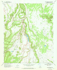
 1969 Coyote Hills1972 Print · USGSApache County's high ranching country is captured here in the late sixties, showing the vital relationship between water and livestock. Researchers can trace the network of corrals and jeep trails connecting Coyote Ranch with water sources like Horseshoe Spring and Coyote Spring.
 - 1969 Map of Eagar, 1972 Print
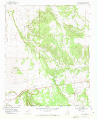
 1969 Eagar1972 Print · USGSIn the late sixties, the Round Valley region of eastern Arizona supported a growing community alongside the high-country ranching tradition. Researchers can locate the Amity Ditch irrigation system, family-named sites like Saffell Knoll, and the Mexican Hay Lake reservoir.2 unique versions available
 - 1969 Map of Springerville, 1972 Print
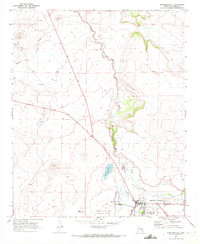 1969 Springerville1972 Print · USGSSpringerville sat at a crossroads of ranching and early aviation in the late sixties, anchored by the high country of Round Valley. Genealogists and historians can trace local landmarks like the town cemetery, the Little Colorado River's path, and Becker Lake.2 unique versions available
 - 1969 Map of Nelson Reservoir, 1972 Print
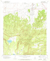
 1969 Nelson Reservoir1972 Print · USGSThe high timberlands of the Apache National Forest are captured here in the late sixties, centered on the vital waters of Nelson Reservoir. Trace early infrastructure and local landmarks like Correjo Crossing, Lockhart Well, and several high-altitude reservoirs.
End of results
Showing maps 1-5 of 5
Top cities near Eagar
Frequently asked questions
- What are the different types of historical maps available for Eagar?
- What is the oldest map of Eagar?
- Where can I purchase historical maps of Eagar for my home or office?
- Where can I download high-res historical maps of Eagar?
- Are there historical topographic maps available for Eagar?
- Is there historical aerial imagery available for Eagar?
- Where are historical maps of Eagar sourced from?