1990s Maps of Eagar, Arizona
Explore 4 historic maps of Eagar from the 1990s. These maps offer a rare glimpse into what life looked like during the 1990s — showing old roads, neighborhoods, homes, and landmarks that have changed or disappeared over time.
Whether you're researching your family's past, planning a metal detecting trip, or studying how Eagar's landscape evolved across the 1990s, these high-resolution maps are a powerful tool for exploring the history of this region.
- Focus on a specific era: All maps on this page are from the 1990s, giving you a focused view of this time period.
- See what’s changed: Compare century-old streets, trails, and buildings to today's modern landscape using overlays and satellite layers.
- Research with precision: Use these maps for genealogy, historical research, land use analysis, or educational projects.
- View, download, or print: Maps are fully viewable online in high resolution, and can be downloaded or printed for your own records.
Start exploring Eagar's history through authentic maps from the 1990s. This is your window into the past.
Eagar, AZ maps
(4)- 1997 Map of Springerville, 2000 Print
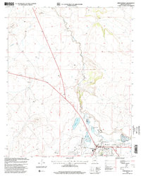 1997 Springerville2000 Print · USGSEastern Arizona's high-country ranching and forest management are documented in this late-century revision of the Round Valley area. Researchers can trace the water rights and boundaries of Springerville through Becker Lake, the Voigt Ranch, and the Little Colorado River corridor.
 - 1997 Map of Coyote Hills, 2000 Print
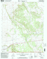 1997 Coyote Hills2000 Print · USGSApache County high country in the late 1990s reveals a landscape of ranching and remote forest tracks. Genealogists and local historians can trace the legacy of Coyote Ranch and the settlement of Coyote near the waters of Nutrioso Creek.
 - 1997 Map of Nelson Reservoir, 2000 Print
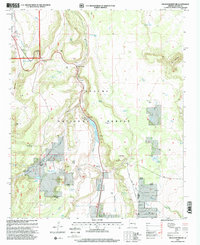 1997 Nelson Reservoir2000 Print · USGSThe Apache National Forest landscape in the 1990s reveals a sophisticated network of ranching and water management. Researchers can trace the legacy of local families and forest use through Butler Cemetery, Herchede Ranch, and the waters of Nelson Reservoir.
 - 1997 Map of Eagar, 2000 Print
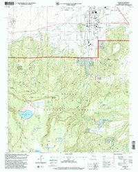 1997 Eagar2000 Print · USGSEagar and the high meadows of the Apache National Forest are documented here in the late nineties as they balance growth with deep-rooted ranching. Researchers can trace local landmarks like Mexican Hay Lake, the Sawmill area, and the Amity Ditch.
End of results
Showing maps 1-4 of 4
Top cities near Eagar
Frequently asked questions
- What are the different types of historical maps available for Eagar?
- What is the oldest map of Eagar?
- Where can I purchase historical maps of Eagar for my home or office?
- Where can I download high-res historical maps of Eagar?
- Are there historical topographic maps available for Eagar?
- Is there historical aerial imagery available for Eagar?
- Where are historical maps of Eagar sourced from?