1900s (20th Century) Maps of Winchester Heights, Arizona
Explore 9 historic maps of Winchester Heights from the 1900s (20th Century). These maps offer a rare glimpse into what life looked like during the 1900s — showing old roads, neighborhoods, homes, and landmarks that have changed or disappeared over time.
Whether you're researching your family's past, planning a metal detecting trip, or studying how Winchester Heights's landscape evolved across the 1900s, these high-resolution maps are a powerful tool for exploring the history of this region.
- Focus on a specific era: All maps on this page are from the 1900s, giving you a focused view of this time period.
- See what’s changed: Compare century-old streets, trails, and buildings to today's modern landscape using overlays and satellite layers.
- Research with precision: Use these maps for genealogy, historical research, land use analysis, or educational projects.
- View, download, or print: Maps are fully viewable online in high resolution, and can be downloaded or printed for your own records.
Start exploring Winchester Heights's history through authentic maps from the 1900s. This is your window into the past.
Winchester Heights, AZ maps
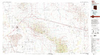
(9)- 1922 Map of Willcox
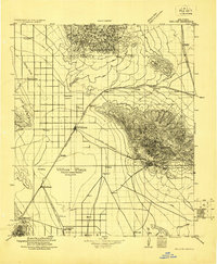 1922 Willcox1922 Print · USGSCochise County’s high-desert ranching and mining heartland is captured in the early 1920s as a thriving railroad hub. Genealogists can trace family holdings and rail stops across the basin, from Willcox and Servoss to the Mascot Mine and Circle I Ranch.
 - 1943 Map of Willcox
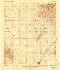 1943 Willcox1943 Print · USGSIn the early 1940s, the cattle ranches and rail lines of southeastern Arizona defined the high desert landscape. Genealogists and researchers can locate family sites like the Brookerson Ranch, follow the Southern Pacific tracks through Raso, or find the Stewart Sch.3 unique versions available
 - 1954 Map of Silver City, 1967 Print
 1954 Silver City1967 Print · USGSSoutheast Arizona and southwest New Mexico meet in this mid-century survey of the high desert and mountain mining districts. Local researchers can trace the rail lines through Lordsburg, the silver operations at Ash Peak Mines, and the limits of Fort Bayard Military Reservation.4 unique versions available
 - 1958 Map of Silver City
 1958 Silver City1958 Print · USGSSouthwestern New Mexico and eastern Arizona appear here in the mid-1950s, a period of intensive mining and rail activity. Trace the routes of the Southern Pacific RR through Lordsburg or locate historic operations at the Chino Mine and Santa Rita.
 - 1958 Map of Willcox, 1959 Print
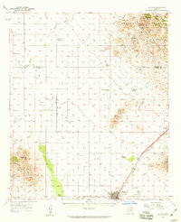 1958 Willcox1959 Print · USGSThe ranching and rail hub of Willcox is captured here in the late fifties, showcasing a landscape of high desert basins and mountain passes. Genealogists and historians can trace legacy cattle operations like Palmer Ranch and family sites such as the Drury settlement.3 unique versions available
 - 1962 Map of Silver City
 1962 Silver City1962 Print · USGSThe high desert borderlands of New Mexico and Arizona come alive in this early sixties survey. Genealogists and historians can trace the mining economy through the Chino Mine, follow the rail routes of the Southern Pacific, or locate settlements like Virden and Bayard.
 - 1985 Map of West of Greasewood Mtn
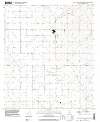
 1985 West of Greasewood Mtn1985 Print · USGSThe high desert along the border of Graham and Cochise counties is captured here in the mid-1980s. Researchers can trace the water-driven development of the region through features like Ash Creek, Bar Wash, and various Storage Bins.
 - 1994 Map of Willcox
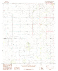
 1994 Willcox1994 Print · USGSSoutheast Arizona in the mid-nineties shows a landscape defined by expansive desert basins and rugged sky islands. Genealogists and historians can trace the rail corridor of the Southern Pacific through Willcox, Bowie, and the Kansas Settlement.2 unique versions available
 - 1996 Map of West of Greasewood Mountain, 2003 Print
 1996 West of Greasewood Mountain2003 Print · USGSThe Cochise and Graham county line in the late nineties reveals a landscape of high-desert ranching and utility infrastructure. Genealogists and researchers can trace local water rights and land use through numerous Wells, livestock Corrals, and the Sulphur BM 4305 marker.
End of results
Showing maps 1-9 of 9
Top cities near Winchester Heights
Frequently asked questions
- What are the different types of historical maps available for Winchester Heights?
- What is the oldest map of Winchester Heights?
- Where can I purchase historical maps of Winchester Heights for my home or office?
- Where can I download high-res historical maps of Winchester Heights?
- Are there historical topographic maps available for Winchester Heights?
- Is there historical aerial imagery available for Winchester Heights?
- Where are historical maps of Winchester Heights sourced from?