1900s (20th Century) Maps of Flagstaff, Arizona
Explore 12 historic maps of Flagstaff from the 1900s (20th Century). These maps offer a rare glimpse into what life looked like during the 1900s — showing old roads, neighborhoods, homes, and landmarks that have changed or disappeared over time.
Whether you're researching your family's past, planning a metal detecting trip, or studying how Flagstaff's landscape evolved across the 1900s, these high-resolution maps are a powerful tool for exploring the history of this region.
- Focus on a specific era: All maps on this page are from the 1900s, giving you a focused view of this time period.
- See what’s changed: Compare century-old streets, trails, and buildings to today's modern landscape using overlays and satellite layers.
- Research with precision: Use these maps for genealogy, historical research, land use analysis, or educational projects.
- View, download, or print: Maps are fully viewable online in high resolution, and can be downloaded or printed for your own records.
Start exploring Flagstaff's history through authentic maps from the 1900s. This is your window into the past.
Flagstaff, AZ maps
(12)- 1908 Map of Flagstaff, 1960 Print
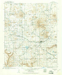 1908 Flagstaff1960 Print · USGSNorthern Arizona's high country is captured here during the early twentieth century, showing the rail and ranching roots of the Coconino plateau. Genealogists and historians can trace early settlements like Bellemont, scientific landmarks like Lowell Observatory, and the timber works at Greenlaw's Mill.
 - 1912 Map of Flagstaff
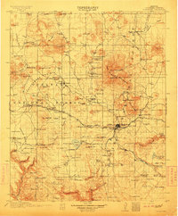 1912 Flagstaff1912 Print · USGSFlagstaff and the surrounding Coconino highlands appear here during a period of steady growth along the railroad. Genealogists and historians can locate early family sites like Darden's Ranch, the Lowell Observatory, and Greenlaw's Mill.5 unique versions available
 - 1947 Map of Flagstaff, 1948 Print
 1947 Flagstaff1948 Print · USGSThe Arizona high country and the Painted Desert converge in this post-war survey. Researchers can trace the ancient mesa villages of Walpi and Oraibi, the early roads of Flagstaff, and landmarks like Sunset Crater National Monument.2 unique versions available
 - 1954 Map of Flagstaff, 1966 Print
 1954 Flagstaff1966 Print · USGSNorthern Arizona in the mid-fifties shows a landscape of volcanic peaks and ancestral mesa villages linked by the iconic U.S. 66. Trace the path of the Atchison Topeka and Santa Fe through Winslow or explore the settlements of Old Oraibi and Kearns Canyon.3 unique versions available
 - 1958 Map of Flagstaff
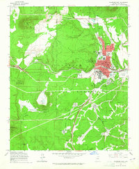
 1958 Flagstaff1958 Print · USGSNorthern Arizona in the late fifties is captured here during the heyday of Route 66 and the expansion of the high desert rail corridors. Researchers can trace historic mesa settlements like Old Oraibi or follow the path of the Atchison Topeka and Santa Fe through Flagstaff and Winslow.
 - 1960 Map of Flagstaff
 1960 Flagstaff1960 Print · USGSNorthern Arizona at the dawn of the sixties shows a landscape defined by mesa-top Hopi villages and the burgeoning railroad hub of Flagstaff. Trace the path of U.S. 66 past Meteor Crater or locate historic trading posts like Gray Mountain Trading Post.2 unique versions available
 - 1962 Map of Flagstaff
 1962 Flagstaff1962 Print · USGSNorthern Arizona in the early sixties showcases the intersection of Tribal lands, national forests, and the busy Route 66 corridor. Trace historic roadside stops and landmarks like Meteor Crater, the Buck-Rodgers Trading Post, and the ancient village of Old Oraibi.
 - 1962 Map of Mountainaire, 1964 Print
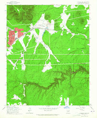
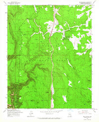 1962 Mountainaire1964 Print · USGSThe high timber country south of Flagstaff in the early sixties reveals a landscape shaped by water management and industry. Researchers can trace the path of the Industrial Railroad and locate specific sites like Gates Cabin, the State Fish Hatchery, and several high-altitude springs.5 unique versions available
 - 1962 Map of Lower Lake Mary, 1964 Print
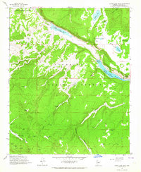 1962 Lower Lake Mary1964 Print · USGSThe Coconino National Forest landscape in the early 1960s reveals a unique intersection of scientific research and high-desert ranching. Genealogists and historians can trace family-named sites like Coulter Cabin and Hoxworth Springs, or locate early scientific facilities such as the Perkins Telescope.4 unique versions available
 - 1962 Map of Flagstaff West, 1965 Print
 1962 Flagstaff West1965 Print · USGSFlagstaff and the surrounding Coconino Forest are captured here during a mid-century era of scientific and collegiate growth. Researchers can trace the development of Arizona State College and search for family roots at Calvary Cemetery or the Lowell Observatory.5 unique versions available
 - 1962 Map of Flagstaff East, 1965 Print
 1962 Flagstaff East1965 Print · USGSFlagstaff was expanding eastward in the early sixties as industrial cinder mining and historic tourism shaped the high plateau. Genealogists and historians can trace the development of East Flagstaff and find landmarks like the Cliff Dwellings and Camp Townsend.6 unique versions available
 - 1982 Map of Flagstaff, 1983 Print
 1982 Flagstaff1983 Print · USGSThe high plateau surrounding Flagstaff is seen here in the early eighties, centered on the intersection of forest, rail, and science. Genealogists and historians can trace the paths of U S 66 and the Atchison Topeka and Santa Fe past landmarks like Two Guns, Bellemont, and Lowell Observatory.2 unique versions available
End of results
Showing maps 1-12 of 12
Top cities near Flagstaff
- Doney Park historical maps
- Kachina Village historical maps
- Timberline-Fernwood historical maps
- Fort Valley historical maps
- Mountain View Ranches historical maps
- Munds Park historical maps
See more
Top neighborhoods of Flagstaff
- Mountian Dell historical maps
- Valley Crest historical maps
- East Flagstaff historical maps
- Coyote Springs historical maps
- Lynwood historical maps
- Cheshire historical maps
See more
Frequently asked questions
- What are the different types of historical maps available for Flagstaff?
- What is the oldest map of Flagstaff?
- Where can I purchase historical maps of Flagstaff for my home or office?
- Where can I download high-res historical maps of Flagstaff?
- Are there historical topographic maps available for Flagstaff?
- Is there historical aerial imagery available for Flagstaff?
- Where are historical maps of Flagstaff sourced from?