1900s (20th Century) Maps of Globe, Arizona
Explore 12 historic maps of Globe from the 1900s (20th Century). These maps offer a rare glimpse into what life looked like during the 1900s — showing old roads, neighborhoods, homes, and landmarks that have changed or disappeared over time.
Whether you're researching your family's past, planning a metal detecting trip, or studying how Globe's landscape evolved across the 1900s, these high-resolution maps are a powerful tool for exploring the history of this region.
- Focus on a specific era: All maps on this page are from the 1900s, giving you a focused view of this time period.
- See what’s changed: Compare century-old streets, trails, and buildings to today's modern landscape using overlays and satellite layers.
- Research with precision: Use these maps for genealogy, historical research, land use analysis, or educational projects.
- View, download, or print: Maps are fully viewable online in high resolution, and can be downloaded or printed for your own records.
Start exploring Globe's history through authentic maps from the 1900s. This is your window into the past.
Globe, AZ maps
(12)- 1901 Map of Globe, 1955 Print
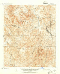 1901 Globe1955 Print · USGSThe Arizona copper belt and the mining town of Globe appear here at the turn of the century during a period of intense industrial expansion. Genealogists and historians can trace early family-held outposts like Horrell's Ranch and major operations including the Old Dominion Mine.2 unique versions available
 - 1902 Map of Globe
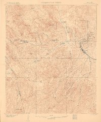 1902 Globe1902 Print · USGSThe mining district of Globe is captured here at the height of its early copper boom. Genealogists and historians can trace the workings of the Old Dominion Mine and Black Warrior, or locate family sites like Pinal Ranch.3 unique versions available
 - 1945 Map of Globe, 1947 Print
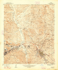 1945 Globe1947 Print · USGSGila County's copper belt is captured here during the height of its mid-century mining boom, showing the complex industrial networks around Globe and Miami. Genealogists and historians can trace residential growth in Midland City and locate landmarks like the Besh-Ba-Gowah Pueblo Ruins.4 unique versions available
 - 1954 Map of Mesa, 1968 Print
 1954 Mesa1968 Print · USGSCentral Arizona in the mid-fifties reveals the rapid growth of the Valley of the Sun alongside the deep-rooted mining districts of the eastern mountains. Genealogists and researchers can trace the expansion of Mesa and Chandler or locate legacy operations at Inspiration Mine and the Magma Arizona railroad.4 unique versions available
 - 1957 Map of Mesa
 1957 Mesa1957 Print · USGSCentral Arizona's desert valleys and high-mountain mining districts come alive in the mid-fifties. Researchers can trace the early layout of Mesa and Phoenix or locate remote sites like Inspiration Mine and Arizona State College.
 - 1958 Map of Mesa
 1958 Mesa1958 Print · USGSMid-century Arizona comes alive in this survey of the valley and high desert, where urban growth begins to transform the landscape. Genealogists and researchers can trace the rail-and-mine economy through Inspiration Mine and old stops like Rittenhouse and Magma.
 - 1960 Map of Mesa
 1960 Mesa1960 Print · USGSThe Salt River Valley and Superstition wilderness are captured here during a era of rapid post-war growth. Researchers can trace the mid-century footprints of Williams AF Base and Arizona State College or locate the deep-rock shafts of the Old Dominion Mine and Magma Mine.
 - 1964 Map of Mesa
 1964 Mesa1964 Print · USGSCentral Arizona in the mid-1960s reveals a landscape defined by rapid desert urbanization and a massive copper mining industry. Genealogists and historians can trace the growth of Phoenix or explore the mining camps and operations at Miami Mine and Magma Mine.
 - 1964 Map of Pinal Peak, 1965 Print
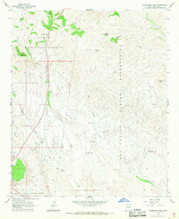
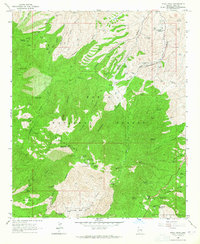 1964 Pinal Peak1965 Print · USGSThe Pinal Mountains rise above the Arizona desert in the early sixties, a landscape of high-altitude lookouts and rugged mining claims. Researchers can trace historic extraction sites like the Azurite Mine and remote outposts such as 66 Ranch or the Signal Peak Lookout Tower.4 unique versions available
 - 1966 Map of Cammerman Wash, 1968 Print
 1966 Cammerman Wash1968 Print · USGSGila County's rugged borderlands come into focus in the mid-sixties as the forest and reservation boundaries align. Genealogists and historians can trace water rights and land use through Wheeler Landing Field, Champion Spring, and the Southern Pacific tracks.2 unique versions available
 - 1966 Map of Cutter, 1968 Print
 1966 Cutter1968 Print · USGSThe ranching and rail landscape of Gila County comes alive in this mid-sixties survey of the high desert. Researchers can trace the path of the Southern Pacific through Cutter or locate family landmarks like Cutter Ranch and the Bar F Bar Ranch.
 - 1986 Map of Globe
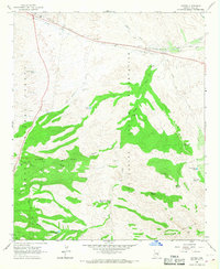
 1986 Globe1986 Print · USGSThe copper districts of Gila County and the lands of the San Carlos Apache are detailed here during the mid-eighties. Researchers can trace the industrial footprint of the Miami Mine, the sprawling San Carlos Reservoir, and small riverside settlements like Bylas and Geronimo.2 unique versions available
End of results
Showing maps 1-12 of 12
Top cities near Globe
Frequently asked questions
- What are the different types of historical maps available for Globe?
- What is the oldest map of Globe?
- Where can I purchase historical maps of Globe for my home or office?
- Where can I download high-res historical maps of Globe?
- Are there historical topographic maps available for Globe?
- Is there historical aerial imagery available for Globe?
- Where are historical maps of Globe sourced from?