1960s Maps of Hayden, Arizona
Explore 5 historic maps of Hayden from the 1960s. These maps offer a rare glimpse into what life looked like during the 1960s — showing old roads, neighborhoods, homes, and landmarks that have changed or disappeared over time.
Whether you're researching your family's past, planning a metal detecting trip, or studying how Hayden's landscape evolved across the 1960s, these high-resolution maps are a powerful tool for exploring the history of this region.
- Focus on a specific era: All maps on this page are from the 1960s, giving you a focused view of this time period.
- See what’s changed: Compare century-old streets, trails, and buildings to today's modern landscape using overlays and satellite layers.
- Research with precision: Use these maps for genealogy, historical research, land use analysis, or educational projects.
- View, download, or print: Maps are fully viewable online in high resolution, and can be downloaded or printed for your own records.
Start exploring Hayden's history through authentic maps from the 1960s. This is your window into the past.
Hayden, AZ maps
(5)- 1960 Map of Mesa
 1960 Mesa1960 Print · USGSThe Salt River Valley and Superstition wilderness are captured here during a era of rapid post-war growth. Researchers can trace the mid-century footprints of Williams AF Base and Arizona State College or locate the deep-rock shafts of the Old Dominion Mine and Magma Mine.
 - 1962 Map of Tucson
 1962 Tucson1962 Print · USGSSouthern Arizona in the early sixties showcases a landscape defined by burgeoning desert cities and massive military installations. Researchers can trace tribal settlements like Schuchk, legacy mining sites at Silver Bell Mine, and the early footprint of Davis-Monthan Air Force Base.
 - 1964 Map of Tucson
 1964 Tucson1964 Print · USGSSouthern Arizona in the mid-1960s shows a landscape of burgeoning desert cities and industrial-scale copper mining. Researchers can trace the development of Tucson and its outlying mining districts, including the Silver Bell Mine and San Manuel Mine.
 - 1964 Map of Mesa
 1964 Mesa1964 Print · USGSCentral Arizona in the mid-1960s reveals a landscape defined by rapid desert urbanization and a massive copper mining industry. Genealogists and historians can trace the growth of Phoenix or explore the mining camps and operations at Miami Mine and Magma Mine.
 - 1964 Map of Hayden, 1965 Print
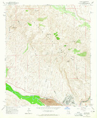 1964 Hayden1965 Print · USGSGila County industrial and mountain landscapes are captured here in the mid-1960s as mining operations dominated the Gila River corridor. Genealogists and industrial historians can trace the rail network of the Southern Pacific serving Hayden and local extraction sites like the 79 Mine or Santa Monica Camp.3 unique versions available
End of results
Showing maps 1-5 of 5
Top cities near Hayden
Frequently asked questions
- What are the different types of historical maps available for Hayden?
- What is the oldest map of Hayden?
- Where can I purchase historical maps of Hayden for my home or office?
- Where can I download high-res historical maps of Hayden?
- Are there historical topographic maps available for Hayden?
- Is there historical aerial imagery available for Hayden?
- Where are historical maps of Hayden sourced from?