1990s Maps of Ponderosa Spring Subdivision, Arizona
Explore 2 historic maps of Ponderosa Spring Subdivision from the 1990s. These maps offer a rare glimpse into what life looked like during the 1990s — showing old roads, neighborhoods, homes, and landmarks that have changed or disappeared over time.
Whether you're researching your family's past, planning a metal detecting trip, or studying how Ponderosa Spring Subdivision's landscape evolved across the 1990s, these high-resolution maps are a powerful tool for exploring the history of this region.
- Focus on a specific era: All maps on this page are from the 1990s, giving you a focused view of this time period.
- See what’s changed: Compare century-old streets, trails, and buildings to today's modern landscape using overlays and satellite layers.
- Research with precision: Use these maps for genealogy, historical research, land use analysis, or educational projects.
- View, download, or print: Maps are fully viewable online in high resolution, and can be downloaded or printed for your own records.
Start exploring Ponderosa Spring Subdivision's history through authentic maps from the 1990s. This is your window into the past.
Ponderosa Spring Subdivision, AZ maps
(2)- 1990 Map of Woods Canyon, 1991 Print
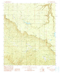 1990 Woods Canyon1991 Print · USGSArizona's high country is defined by the massive escarpment of the Mogollon Rim during the late twentieth century. Researchers can trace the developed recreation landscape of the era, from the Woods Canyon Dam and Willow Springs Lake to the rugged Military Sinkhole.2 unique versions available
 - 1998 Map of Woods Canyon, 2001 Print
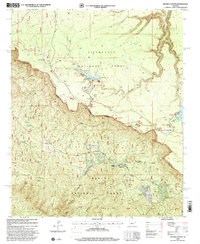 1998 Woods Canyon2001 Print · USGSThe Mogollon Rim forms a dramatic divide through the Arizona high country during the late twentieth century. Researchers can trace historic routes like the General George Crook Road and locate mountain communities at Colcord Estates or Ponderosa Estates.
End of results
Showing maps 1-2 of 2
Frequently asked questions
- What are the different types of historical maps available for Ponderosa Spring Subdivision?
- What is the oldest map of Ponderosa Spring Subdivision?
- Where can I purchase historical maps of Ponderosa Spring Subdivision for my home or office?
- Where can I download high-res historical maps of Ponderosa Spring Subdivision?
- Are there historical topographic maps available for Ponderosa Spring Subdivision?
- Is there historical aerial imagery available for Ponderosa Spring Subdivision?
- Where are historical maps of Ponderosa Spring Subdivision sourced from?