1970s Maps of Star Valley, Arizona
Explore 4 historic maps of Star Valley from the 1970s. These maps offer a rare glimpse into what life looked like during the 1970s — showing old roads, neighborhoods, homes, and landmarks that have changed or disappeared over time.
Whether you're researching your family's past, planning a metal detecting trip, or studying how Star Valley's landscape evolved across the 1970s, these high-resolution maps are a powerful tool for exploring the history of this region.
- Focus on a specific era: All maps on this page are from the 1970s, giving you a focused view of this time period.
- See what’s changed: Compare century-old streets, trails, and buildings to today's modern landscape using overlays and satellite layers.
- Research with precision: Use these maps for genealogy, historical research, land use analysis, or educational projects.
- View, download, or print: Maps are fully viewable online in high resolution, and can be downloaded or printed for your own records.
Start exploring Star Valley's history through authentic maps from the 1970s. This is your window into the past.
Star Valley, AZ maps
(4)- 1973 Map of Diamond Point, 1975 Print
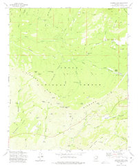 1973 Diamond Point1975 Print · USGSGila County ranching and forest lands are detailed in this early 1970s survey. Genealogists and local historians can trace family-named sites like Pyle Ranch, Yunker Ranch Well, and the prominent lookout at Diamond Point.2 unique versions available
 - 1973 Map of McDonald Mtn, 1975 Print
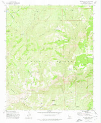 1973 McDonald Mtn1975 Print · USGSGila County ranching and forest lands are captured here in the 1970s, revealing the isolated homesteads and livestock tanks of the Arizona high country. Researchers can trace the location of the Old Rock House, Neal Cabin, and the sprawling Green Valley cattle country.
 - 1973 Map of Payson North, 1975 Print
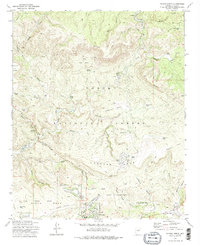 1973 Payson North1975 Print · USGSThe Gila County high country comes into focus in the 1970s as Payson expands toward the northern wilderness. Researchers can trace early residential developments and find specialized sites like the Seismological Observatory and the Sycamore Forest Camp.2 unique versions available
 - 1973 Map of Payson South, 1975 Print
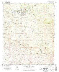 1973 Payson South1975 Print · USGSThe high country of Gila County is captured here in the early seventies, showing Payson as it expands into the Tonto National Forest. Researchers can locate Ft McDonald (Ruins), the Payson Cem, and numerous historic workings like the Golden Wonder Mine.2 unique versions available
End of results
Showing maps 1-4 of 4
Top cities near Star Valley
Frequently asked questions
- What are the different types of historical maps available for Star Valley?
- What is the oldest map of Star Valley?
- Where can I purchase historical maps of Star Valley for my home or office?
- Where can I download high-res historical maps of Star Valley?
- Are there historical topographic maps available for Star Valley?
- Is there historical aerial imagery available for Star Valley?
- Where are historical maps of Star Valley sourced from?