1990s Maps of Carlton Vista, Arizona
Explore 2 historic maps of Carlton Vista from the 1990s. These maps offer a rare glimpse into what life looked like during the 1990s — showing old roads, neighborhoods, homes, and landmarks that have changed or disappeared over time.
Whether you're researching your family's past, planning a metal detecting trip, or studying how Carlton Vista's landscape evolved across the 1990s, these high-resolution maps are a powerful tool for exploring the history of this region.
- Focus on a specific era: All maps on this page are from the 1990s, giving you a focused view of this time period.
- See what’s changed: Compare century-old streets, trails, and buildings to today's modern landscape using overlays and satellite layers.
- Research with precision: Use these maps for genealogy, historical research, land use analysis, or educational projects.
- View, download, or print: Maps are fully viewable online in high resolution, and can be downloaded or printed for your own records.
Start exploring Carlton Vista's history through authentic maps from the 1990s. This is your window into the past.
Carlton Vista, AZ maps
(2)- 1991 Map of Beaverhead
 1991 Beaverhead1991 Print · USGSEastern Arizona high country is mapped here in the early nineties, showing a landscape defined by the drainage of Beaver Creek and Foote Creek. Trace backcountry routes through Apache National Forest to find Cleveland Spring, Castle Rock, and the Devils Washboard.2 unique versions available
 - 1997 Map of Beaverhead, 2000 Print
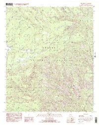
 1997 Beaverhead2000 Print · USGSGreenlee County’s high country is captured here during the late twentieth century, showing a landscape of forest management and ranching. Researchers can locate remote landmarks like the Buckalou Corral, Beaverhead settlement, and the Carlton Vista Overlook.
End of results
Showing maps 1-2 of 2
Top cities near Carlton Vista
Frequently asked questions
- What are the different types of historical maps available for Carlton Vista?
- What is the oldest map of Carlton Vista?
- Where can I purchase historical maps of Carlton Vista for my home or office?
- Where can I download high-res historical maps of Carlton Vista?
- Are there historical topographic maps available for Carlton Vista?
- Is there historical aerial imagery available for Carlton Vista?
- Where are historical maps of Carlton Vista sourced from?