1950s Maps of Goodyear, Arizona
Explore 13 historic maps of Goodyear from the 1950s. These maps offer a rare glimpse into what life looked like during the 1950s — showing old roads, neighborhoods, homes, and landmarks that have changed or disappeared over time.
Whether you're researching your family's past, planning a metal detecting trip, or studying how Goodyear's landscape evolved across the 1950s, these high-resolution maps are a powerful tool for exploring the history of this region.
- Focus on a specific era: All maps on this page are from the 1950s, giving you a focused view of this time period.
- See what’s changed: Compare century-old streets, trails, and buildings to today's modern landscape using overlays and satellite layers.
- Research with precision: Use these maps for genealogy, historical research, land use analysis, or educational projects.
- View, download, or print: Maps are fully viewable online in high resolution, and can be downloaded or printed for your own records.
Start exploring Goodyear's history through authentic maps from the 1950s. This is your window into the past.
Goodyear, AZ maps
(13)- 1951 Map of Mobile
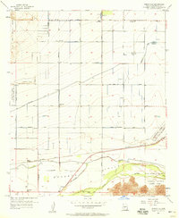
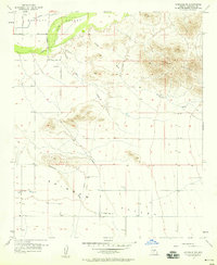
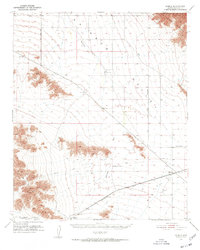 1951 Mobile1951 Print · USGSRainbow Valley and the surrounding desert peaks are captured here in the early 1950s, showing a landscape shaped by rail and stage routes. You can trace the historic Butterfield Stage Line and locate small rail sidings like Mobile and Estrella.3 unique versions available
 - 1952 Map of Montezuma Peak, 1957 Print
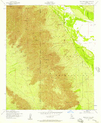 1952 Montezuma Peak1957 Print · USGSThe Sierra Estrella range and Gila River Indian Reservation are captured here in the early fifties before modern expansion. Historians and genealogists can trace early landmarks like St Catherines Ch, the Crushed Mica Quarry, and the Santa Cruz settlement along the Santa Cruz Wash.3 unique versions available
 - 1952 Map of Enid, 1957 Print
 1952 Enid1957 Print · USGSThe Pinal County desert comes into focus in the early 1950s, showing the intersection of tribal lands and railroad expansion. Researchers can trace the rail stops at Enid and Heaton or locate historical sites like Wiley Ranch and a Race Track (Aban'd).3 unique versions available
 - 1952 Map of Maricopa, 1959 Print
 1952 Maricopa1959 Print · USGSArizona's Sonoran Desert meets the iron rail in the early 1950s, showing a landscape defined by tribal reservations and mountain peaks. Researchers can trace the Southern Pacific line through Maricopa or locate the St Francis Mission and Wiley Ranch.2 unique versions available
 - 1954 Map of Phoenix, 1964 Print
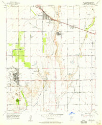
 1954 Phoenix1964 Print · USGSMid-century Arizona is captured here as the Phoenix metropolitan area begins its rapid expansion into the surrounding desert. Genealogists and historians can trace the development of agricultural hubs like Buckeye and Tolleson, or locate remote landmarks like the Vulture Mine and Nottbusch Cem.5 unique versions available
 - 1957 Map of Phoenix
 1957 Phoenix1957 Print · USGSGreater Phoenix and the central Arizona desert during the mid-fifties reveal a landscape of growing suburbs and active desert mines. Researchers can trace the legacy of local landmarks like Wickenburg Prison, the Vulture Mine, and the Tonopah Post Office.
 - 1957 Map of Perryville, 1958 Print
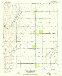
 1957 Perryville1958 Print · USGSMaricopa County agriculture and irrigation were in full swing during the late fifties, long before modern suburban expansion. Genealogists and local historians can trace the early layout of Perryville and McMicken alongside complex networks of wells and reservoirs.5 unique versions available
 - 1957 Map of El Mirage, 1958 Print
 1957 El Mirage1958 Print · USGSMaricopa County's West Valley comes into focus in the mid-fifties as agriculture and military aviation shape the desert landscape. Genealogists and historians can trace the early footprints of Surprise and El Mirage, or locate specific sites like the Heath Grave and the Dysart Sch.5 unique versions available
 - 1957 Map of Waddell, 1958 Print
 1957 Waddell1958 Print · USGSMaricopa County's western desert fringe comes alive in the late fifties, showing a landscape defined by military flight paths and mountain flood control. Trace the rail-side growth of Waddell and Fennemore or locate the early footprint of Luke Air Force Base.4 unique versions available
 - 1957 Map of Tolleson, 1958 Print
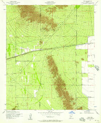
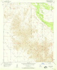
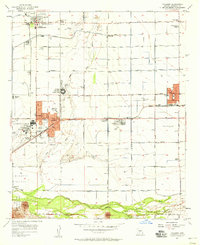 1957 Tolleson1958 Print · USGSThe West Valley was a thriving agricultural hub in the late fifties, defined by its railroad towns and river junctions. Genealogists and local historians can trace the early footprints of Avondale, Goodyear, and Tolleson along the Southern Pacific line.5 unique versions available
 - 1957 Map of Avondale SW, 1958 Print
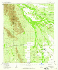
 1957 Avondale SW1958 Print · USGSThe Gila River corridor and the Sierra Estrella foothills are captured here in the late fifties, showing the desert's early transition to managed infrastructure. Trace the early routes of Jackrabbit Trail and Lower River Road, or locate the Liberty Cem and various remote landing strips.5 unique versions available
 - 1957 Map of Avondale SE, 1958 Print
 1957 Avondale SE1958 Print · USGSThe Sierra Estrella and Rainbow Valley are captured here in the late fifties, showing a landscape defined by the Gila and Salt River Meridian. Researchers can trace the Gila River Indian Reservation Boundary or locate Mines and the settlement of Corgett.4 unique versions available
 - 1958 Map of Phoenix
 1958 Phoenix1958 Print · USGSThe Phoenix Valley enters a period of postwar expansion, where desert irrigation meets massive military aviation footprints. Trace the development of Phoenix and Glendale alongside the legendary Vulture Mine and the auxiliary runways of Luke Air Force Base.
End of results
Showing maps 1-13 of 13
Top cities near Goodyear
- Phoenix historical maps
- Buckeye historical maps
- Avondale historical maps
- Maricopa historical maps
- Estrella historical maps
- Tolleson historical maps
See more
Top neighborhoods of Goodyear
- Litchfield historical maps
- Rainbow Valley historical maps
- Estrella historical maps
- Mobile historical maps
- Estrella Vista historical maps
- Las Ventanas historical maps
See more
Frequently asked questions
- What are the different types of historical maps available for Goodyear?
- What is the oldest map of Goodyear?
- Where can I purchase historical maps of Goodyear for my home or office?
- Where can I download high-res historical maps of Goodyear?
- Are there historical topographic maps available for Goodyear?
- Is there historical aerial imagery available for Goodyear?
- Where are historical maps of Goodyear sourced from?