1950s Maps of Peoria, Arizona
Explore 7 historic maps of Peoria from the 1950s. These maps offer a rare glimpse into what life looked like during the 1950s — showing old roads, neighborhoods, homes, and landmarks that have changed or disappeared over time.
Whether you're researching your family's past, planning a metal detecting trip, or studying how Peoria's landscape evolved across the 1950s, these high-resolution maps are a powerful tool for exploring the history of this region.
- Focus on a specific era: All maps on this page are from the 1950s, giving you a focused view of this time period.
- See what’s changed: Compare century-old streets, trails, and buildings to today's modern landscape using overlays and satellite layers.
- Research with precision: Use these maps for genealogy, historical research, land use analysis, or educational projects.
- View, download, or print: Maps are fully viewable online in high resolution, and can be downloaded or printed for your own records.
Start exploring Peoria's history through authentic maps from the 1950s. This is your window into the past.
Peoria, AZ maps
(7)- 1954 Map of Phoenix, 1964 Print
 1954 Phoenix1964 Print · USGSMid-century Arizona is captured here as the Phoenix metropolitan area begins its rapid expansion into the surrounding desert. Genealogists and historians can trace the development of agricultural hubs like Buckeye and Tolleson, or locate remote landmarks like the Vulture Mine and Nottbusch Cem.5 unique versions available
 - 1957 Map of Phoenix
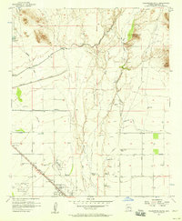
 1957 Phoenix1957 Print · USGSGreater Phoenix and the central Arizona desert during the mid-fifties reveal a landscape of growing suburbs and active desert mines. Researchers can trace the legacy of local landmarks like Wickenburg Prison, the Vulture Mine, and the Tonopah Post Office.
 - 1957 Map of Calderwood Butte, 1958 Print
 1957 Calderwood Butte1958 Print · USGSThe northwest corner of the Salt River Valley appears in the late 1950s as desert ranching meets early suburban growth. Trace the origins of Surprise and Lizard Acres, or locate the Sunrise Relief Mine and various Indian ruins near Calderwood Butte.6 unique versions available
 - 1957 Map of El Mirage, 1958 Print
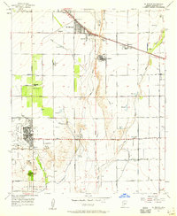 1957 El Mirage1958 Print · USGSMaricopa County's West Valley comes into focus in the mid-fifties as agriculture and military aviation shape the desert landscape. Genealogists and historians can trace the early footprints of Surprise and El Mirage, or locate specific sites like the Heath Grave and the Dysart Sch.5 unique versions available
 - 1957 Map of Hedgpeth Hills, 1958 Print
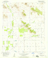 1957 Hedgpeth Hills1958 Print · USGSNorth of Glendale in the late fifties, this landscape shows the desert floor before total suburbanization. Genealogists and historians can trace the early irrigation and road networks around Sierra Vista School, the Arizona Canal, and Thunderbird Park.5 unique versions available
 - 1957 Map of Glendale, 1958 Print
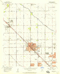 1957 Glendale1958 Print · USGSMaricopa County's citrus and cotton fields meet the growing suburbs of Glendale and Peoria during the late fifties. Trace early school sites like Union High Sch and industrial landmarks from the Agua Fria Steam Plant to the Cotton Gin.6 unique versions available
 - 1958 Map of Phoenix
 1958 Phoenix1958 Print · USGSThe Phoenix Valley enters a period of postwar expansion, where desert irrigation meets massive military aviation footprints. Trace the development of Phoenix and Glendale alongside the legendary Vulture Mine and the auxiliary runways of Luke Air Force Base.
End of results
Showing maps 1-7 of 7
Top cities near Peoria
- Phoenix historical maps
- Glendale historical maps
- Surprise historical maps
- Buckeye historical maps
- Sun City historical maps
- Sun City CDP historical maps
See more
Top neighborhoods of Peoria
- Westbrook Village historical maps
- Pioneer Village II historical maps
- Tuscany Shores at Desert Harbor historical maps
- Braemar VII historical maps
- Bristle Manor historical maps
- Olive West historical maps
See more
Frequently asked questions
- What are the different types of historical maps available for Peoria?
- What is the oldest map of Peoria?
- Where can I purchase historical maps of Peoria for my home or office?
- Where can I download high-res historical maps of Peoria?
- Are there historical topographic maps available for Peoria?
- Is there historical aerial imagery available for Peoria?
- Where are historical maps of Peoria sourced from?