1960s Maps of Peoria, Arizona
Explore 8 historic maps of Peoria from the 1960s. These maps offer a rare glimpse into what life looked like during the 1960s — showing old roads, neighborhoods, homes, and landmarks that have changed or disappeared over time.
Whether you're researching your family's past, planning a metal detecting trip, or studying how Peoria's landscape evolved across the 1960s, these high-resolution maps are a powerful tool for exploring the history of this region.
- Focus on a specific era: All maps on this page are from the 1960s, giving you a focused view of this time period.
- See what’s changed: Compare century-old streets, trails, and buildings to today's modern landscape using overlays and satellite layers.
- Research with precision: Use these maps for genealogy, historical research, land use analysis, or educational projects.
- View, download, or print: Maps are fully viewable online in high resolution, and can be downloaded or printed for your own records.
Start exploring Peoria's history through authentic maps from the 1960s. This is your window into the past.
Peoria, AZ maps
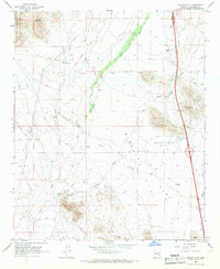
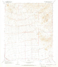
(8)- 1960 Map of Phoenix
 1960 Phoenix1960 Print · USGSCentral Arizona in the mid-fifties reveals a landscape of rapid suburban growth alongside enduring desert mining and ranching. Genealogists and historians can trace rail-side settlements like Vicksburg Junction and Waddell, or locate the Vulture Mine and early sites like Agua Fria School.
 - 1964 Map of Garfias Mountain, 1965 Print
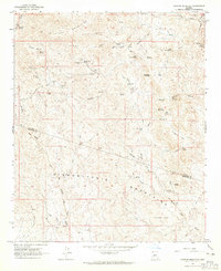 1964 Garfias Mountain1965 Print · USGSThe Arizona desert at the boundary of Yavapai and Maricopa counties is captured here in the mid-1960s. Researchers can trace the legacy of local mining at the St Anthony Mine and Morgan City Mine, or locate family landmarks like L Ranch and Ramon Tank.3 unique versions available
 - 1964 Map of New River, 1965 Print
 1964 New River1965 Print · USGSMaricopa County's northern desert landscape comes into focus during the mid-sixties as the community of New River begins to take shape. Genealogists and historians can trace early landmarks like New River Sch, the Little Grand Canyon Rancho, and scattered Ruins near the Agua Fria River.5 unique versions available
 - 1964 Map of Governors Peak, 1965 Print
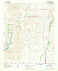
 1964 Governors Peak1965 Print · USGSThe Arizona desert at the Yavapai and Maricopa county line reveals a landscape of remote ranches and ancient rock art in the mid-1960s. Genealogists and historians can trace routes to Castle Hot Springs, locate Petroglyphs, and explore the shoreline of Lake Pleasant.5 unique versions available
 - 1964 Map of Baldy Mtn, 1965 Print
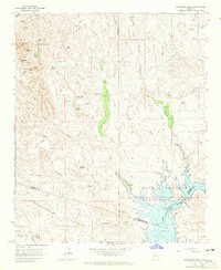
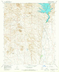 1964 Baldy Mtn1965 Print · USGSMaricopa County during the 1960s shows a landscape of desert mining and expanding water infrastructure along the Agua Fria River. Researchers can trace early recreational development at Lake Pleasant and locate industrial sites like the White Peak Mine and White Peak Quarry.4 unique versions available
 - 1965 Map of Biscuit Flat, 1966 Print
 1965 Biscuit Flat1966 Print · USGSMaricopa County's arid northern reaches are shown here in the mid-sixties, a landscape of ranching tanks and desert washes. Trace the paths of New River and Skunk Creek past local landmarks like Black Mountain and the Black Canyon Shooting Range.3 unique versions available
 - 1965 Map of Hieroglyphic Mts. SW, 1967 Print
 1965 Hieroglyphic Mts. SW1967 Print · USGSMaricopa County's arid northern reaches are captured in the mid-sixties, showing a landscape defined by the Hieroglyphic Mts. and seasonal drainage. Genealogists and desert historians can trace the infrastructure of English Camp, the isolated tracks of Nada, and a lonely Grave south of Padelford Wash.3 unique versions available
 - 1969 Map of Phoenix, 1970 Print
 1969 Phoenix1970 Print · USGSCentral Arizona is seen at a technological turning point in the late sixties, using Apollo 9 space photography to map the desert landscape. Researchers can trace the growth of Sun City, locate old workings at Vulture Mine, and follow the Gila River past Buckeye.2 unique versions available
End of results
Showing maps 1-8 of 8
Top cities near Peoria
- Phoenix historical maps
- Glendale historical maps
- Surprise historical maps
- Buckeye historical maps
- Sun City historical maps
- Sun City CDP historical maps
See more
Top neighborhoods of Peoria
- Westbrook Village historical maps
- Pioneer Village II historical maps
- Tuscany Shores at Desert Harbor historical maps
- Braemar VII historical maps
- Bristle Manor historical maps
- Olive West historical maps
See more
Frequently asked questions
- What are the different types of historical maps available for Peoria?
- What is the oldest map of Peoria?
- Where can I purchase historical maps of Peoria for my home or office?
- Where can I download high-res historical maps of Peoria?
- Are there historical topographic maps available for Peoria?
- Is there historical aerial imagery available for Peoria?
- Where are historical maps of Peoria sourced from?