1970s Maps of Queen Creek, Arizona
Explore 4 historic maps of Queen Creek from the 1970s. These maps offer a rare glimpse into what life looked like during the 1970s — showing old roads, neighborhoods, homes, and landmarks that have changed or disappeared over time.
Whether you're researching your family's past, planning a metal detecting trip, or studying how Queen Creek's landscape evolved across the 1970s, these high-resolution maps are a powerful tool for exploring the history of this region.
- Focus on a specific era: All maps on this page are from the 1970s, giving you a focused view of this time period.
- See what’s changed: Compare century-old streets, trails, and buildings to today's modern landscape using overlays and satellite layers.
- Research with precision: Use these maps for genealogy, historical research, land use analysis, or educational projects.
- View, download, or print: Maps are fully viewable online in high resolution, and can be downloaded or printed for your own records.
Start exploring Queen Creek's history through authentic maps from the 1970s. This is your window into the past.
Queen Creek, AZ maps
(4)- 1971 Map of Higley, 1972 Print
 1971 Higley1972 Print · USGSMaricopa County agriculture and military aviation are captured in detail during the early seventies. Genealogists and historians can trace the footprint of Higley and the sprawling layout of Williams Air Force Base at the height of its activity.
 - 1971 Map of Sacaton NE, 1972 Print
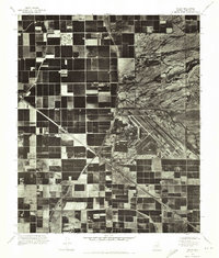
 1971 Sacaton NE1972 Print · USGSPinal County agriculture meets the desert foothills in the early seventies, capturing the precise layout of Arizona’s irrigation-driven landscape. You can trace the path of Queen Creek and the rising slopes of Goldmine Mountain amidst the geometric farm grids.
 - 1971 Map of Desert Well, 1972 Print
 1971 Desert Well1972 Print · USGSIn the early 1970s, the landscape around Pinal and Maricopa counties was a mix of military testing and expanding desert agriculture. Researchers can trace the layout of the Desert Proving Grounds and the runway at Rittenhouse Air Force Auxiliary Field.
 - 1971 Map of Chandler Heights, 1972 Print
 1971 Chandler Heights1972 Print · USGSThe agricultural grid and desert foothills of Pinal and Maricopa counties are seen in detail in the early 1970s. Researchers can trace the layout of citrus groves in Chandler Heights and the drainage patterns of Queen Creek below the Goldmine Mountains.
End of results
Showing maps 1-4 of 4
Top cities near Queen Creek
- Mesa historical maps
- Chandler historical maps
- Gilbert historical maps
- San Tan Valley historical maps
- Apache Junction historical maps
- Florence historical maps
See more
Top neighborhoods of Queen Creek
- Dorada Estates historical maps
- Queen Creek Ranchettes historical maps
- Sanokai Village historical maps
- Seasons at Spur Cross historical maps
- Homestead at Spur Cross historical maps
- Spur Cross historical maps
See more
Frequently asked questions
- What are the different types of historical maps available for Queen Creek?
- What is the oldest map of Queen Creek?
- Where can I purchase historical maps of Queen Creek for my home or office?
- Where can I download high-res historical maps of Queen Creek?
- Are there historical topographic maps available for Queen Creek?
- Is there historical aerial imagery available for Queen Creek?
- Where are historical maps of Queen Creek sourced from?