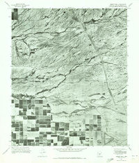
1971 Map of Desert Well
USGS Topo · Published 1972About this map
Desert Proving Grounds and its distinctive circular tracks dominate the arid landscape in this orthophotoquad, captured at a moment when the desert was beginning to yield to organized agriculture. The southern half of the map reveals a stark contrast, where the scrubland gives way to a grid of irrigated fields that stretch toward the Rittenhouse Air Force Auxiliary Field. This transition from the open range of Desert Well to intensive land use is intersected by the winding path of Siphon Draw, a natural drainage that cuts through the northern terrain. The aerial imagery provides a rare literal look at the physical boundaries between military testing sites and the expanding rural farming footprint in Pinal and Maricopa counties during the early 1970s.
Find a feature on this map
4 named features on this map. Tap any name to fly to it.
Don’t see what you’re looking for? This feature index may not catch every label — zoom into the map to look around manually.
Map Details
Editions of this 1971 Desert Well Map
This is the sole edition of this map. No revisions or reprints were ever made.
Other maps of this area

1900 · Florence
USGS Topo · 1:125,000

1902 · Florence
USGS Topo · 1:125,000

1904 · Desert Well
USGS Topo · 1:62,500

1906 · Desert Well
USGS Topo · 1:62,500

1907 · Sacaton
USGS Topo · 1:62,500

1954 · Mesa
USGS Topo · 1:250,000

1956 · Sacaton NE
USGS Topo · 1:24,000
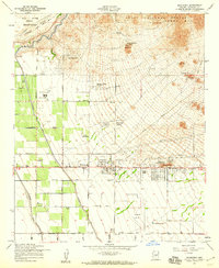
1956 · Buckhorn
USGS Topo · 1:24,000

1956 · Goldfield
USGS Topo · 1:24,000

1956 · Magma
USGS Topo · 1:24,000