1956 Map of Sacaton NE
USGS Topo · Published 1959About this map
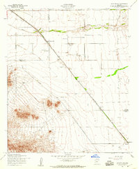
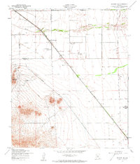
Goldmine Mountain dominates the southwestern corner of this mid-century landscape, overlooking an area where desert terrain meets the expanding infrastructure of the Gila River Valley. The Southern Pacific railroad cuts a diagonal line across the quadrangle, serving local agricultural and industrial needs through stops like Queen Creek Siding and the settlement of Magma. Water management is a critical theme of the era, visible in the presence of a Diversion Dike and the seasonal path of Queen Creek, which is flanked by occasional vegetation.
Find a feature on this map
16 named features on this map. Tap any name to fly to it.
Don’t see what you’re looking for? This feature index may not catch every label — zoom into the map to look around manually.
Map Details
Editions of this 1956 Sacaton NE Map
4 editions found

Historical Maps of San Tan Valley Through Time
439 maps found

1910 Ray
Pinal County, AZ

1914 Gila Butte
Pinal County, AZ

1917 Gila Butte
Pinal County, AZ

1922 Red Rock No 2
Pinal County, AZ

1922 Signal Peak
Pinal County, AZ

1924 Signal Peak
Pinal County, AZ

1934 Newman Peak
Pinal County, AZ

1941 Vekol Mountains
Pinal County, AZ

1942 Silver Reef Mountains
Pinal County, AZ

1942 Vekol Mountains
Pinal County, AZ

1946 Antelope Peak
Pinal County, AZ

1948 Antelope Peak
Pinal County, AZ

1948 Clark Ranch
Pinal County, AZ

1948 Haunted Canyon
Pinal County, AZ

1948 Iron Mountain
Pinal County, AZ

1948 Peppersauce Wash
Pinal County, AZ

1948 Picketpost Mtn
Pinal County, AZ

1949 Black Mountain
Pinal County, AZ

1949 Brandenburg Mtn
Pinal County, AZ

1949 Clark Ranch
Pinal County, AZ

1949 Crozier Peak
Pinal County, AZ

1949 Haunted Canyon
Pinal County, AZ

1949 Holy Joe Peak
Pinal County, AZ

1949 Holy Joe Peak
Pinal County, AZ

1949 Iron Mountain
Pinal County, AZ

1949 Lookout Mtn
Pinal County, AZ

1949 Peppersauce Wash
Pinal County, AZ

1949 Picketpost Mtn
Pinal County, AZ

1949 Putnam Wash
Pinal County, AZ

1950 Black Mountain
Pinal County, AZ

1950 Brandenburg Mtn
Pinal County, AZ

1950 Crozier Peak
Pinal County, AZ

1950 Holy Joe Peak
Pinal County, AZ

1950 Lookout Mtn
Pinal County, AZ

1950 Putnam Wash
Pinal County, AZ

1950 Saddle Mtn.
Pinal County, AZ

1952 Enid
Pinal County, AZ

1952 Gila Butte NW
Pinal County, AZ

1952 Gila Butte
Pinal County, AZ

1952 Gila Butte
Pinal County, AZ

1952 Gila Butte SE
Pinal County, AZ

1952 Montezuma Peak
Pinal County, AZ

1952 Pima Butte
Pinal County, AZ

1952 Sacaton Butte
Pinal County, AZ

1956 Chandler Heights
Pinal County, AZ

1956 Desert Well
Pinal County, AZ

1956 Goldfield
Pinal County, AZ

1956 Magma
Pinal County, AZ

1956 Sacaton NE
Pinal County, AZ

1956 Superstition Mts. SW
Pinal County, AZ

1959 Tortolita Mts
Pinal County, AZ

1963 Antelope Peak
Pinal County, AZ

1963 Silver Reef Mts
Pinal County, AZ

1963 Vekol Mountains
Pinal County, AZ

1964 Grayback
Pinal County, AZ

1964 Hot Tamale Peak
Pinal County, AZ

1964 Mineral Mtn
Pinal County, AZ

1964 North Butte
Pinal County, AZ

1964 Teapot Mountain
Pinal County, AZ

1964 Valley Farms
Pinal County, AZ

1965 Casa Grande East
Pinal County, AZ

1965 Casa Grande Mts
Pinal County, AZ

1965 Casa Grande West
Pinal County, AZ

1965 Double Peak
Pinal County, AZ

1965 Eloy North
Pinal County, AZ

1965 Florence SE
Pinal County, AZ

1965 Picacho Reservoir
Pinal County, AZ

1966 Florence Junction
Pinal County, AZ

1966 Florence NE
Pinal County, AZ

1966 Ninetysix Hills NE
Pinal County, AZ

1966 Ninetysix Hills NW
Pinal County, AZ

1966 Ninetysix Hills SE
Pinal County, AZ

1966 Ninetysix Hills SW
Pinal County, AZ

1966 Picacho Reservoir SE
Pinal County, AZ

1966 Weavers Needle
Pinal County, AZ

1968 Christmas
Pinal County, AZ

1968 Jerusalem Mtn.
Pinal County, AZ

1968 Picacho Reservoir
Pinal County, AZ

1971 Antelope Peak NE
Pinal County, AZ

1971 Casa Grande East
Pinal County, AZ

1971 Casa Grande West
Pinal County, AZ

1971 Chandler Heights
Pinal County, AZ

1971 Desert Well
Pinal County, AZ

1971 Enid
Pinal County, AZ

1971 Gila Butte NW
Pinal County, AZ

1971 Gila Butte
Pinal County, AZ

1971 Gila Butte SE
Pinal County, AZ

1971 Montezuma Peak
Pinal County, AZ

1971 Pima Butte
Pinal County, AZ

1971 Sacaton Butte
Pinal County, AZ

1971 Sacaton NE
Pinal County, AZ

1980 Picacho Pass
Pinal County, AZ

1981 Antelope Peak NE
Pinal County, AZ

1981 Antelope Peak
Pinal County, AZ

1981 Copperosity Hills
Pinal County, AZ

1981 Eloy NW
Pinal County, AZ

1981 Eloy South
Pinal County, AZ

1981 Friendly Corners
Pinal County, AZ

1981 Greene Reservoir
Pinal County, AZ

1981 Haley Hills
Pinal County, AZ

1981 Indian Butte
Pinal County, AZ

1981 Little Table Top
Pinal County, AZ

1981 Newman Peak
Pinal County, AZ

1981 North Komelik
Pinal County, AZ

1981 Samaniego Hills
Pinal County, AZ

1981 Silver Reef Mts.
Pinal County, AZ

1981 Silver Reef Mts. SE
Pinal County, AZ

1981 Vekol Mts. NE
Pinal County, AZ

1988 Chief Butte
Pinal County, AZ

1988 Desert Peak
Pinal County, AZ

1988 Durham Hills
Pinal County, AZ

1988 Fortified Peak
Pinal County, AZ

1988 North of Oracle
Pinal County, AZ

1988 Oracle Junction
Pinal County, AZ

1988 Tortolita Mountains
Pinal County, AZ

1992 Casa Grande East
Pinal County, AZ

1992 Casa Grande Mountains
Pinal County, AZ

1992 Casa Grande West
Pinal County, AZ

1992 Double Peak
Pinal County, AZ

1992 Eloy North
Pinal County, AZ

1992 Picacho Reservoir
Pinal County, AZ

1992 Valley Farms
Pinal County, AZ

1996 Chief Butte
Pinal County, AZ

1996 Desert Peak
Pinal County, AZ

1996 Durham Hills
Pinal County, AZ

1996 Eloy South
Pinal County, AZ

1996 Fortified Peak
Pinal County, AZ

1996 Friendly Corners
Pinal County, AZ

1996 Greene Reservoir
Pinal County, AZ

1996 Newman Peak
Pinal County, AZ

1996 North Komelik
Pinal County, AZ

1996 North of Oracle
Pinal County, AZ

1996 Oracle Junction
Pinal County, AZ

1996 Peppersauce Wash
Pinal County, AZ

1996 Picacho Pass
Pinal County, AZ

1996 Samaniego Hills
Pinal County, AZ

1996 Silver Reef Mountains
Pinal County, AZ

1996 Silver Reef Mountains SE
Pinal County, AZ

1996 Tortolita Mountains
Pinal County, AZ

1997 Ninetysix Hills NE
Pinal County, AZ

2004 Florence Junction
Pinal County, AZ

2004 Goldfield
Pinal County, AZ

2004 Haunted Canyon
Pinal County, AZ

2004 Iron Mountain
Pinal County, AZ

2004 Mineral Mountain
Pinal County, AZ

2004 Picketpost Mountain
Pinal County, AZ

2004 Teapot Mountain
Pinal County, AZ

2004 Weavers Needle
Pinal County, AZ

2011 Antelope Peak NE
Pinal County, AZ

2011 Antelope Peak
Pinal County, AZ

2011 Black Mountain
Pinal County, AZ

2011 Brandenburg Mountain
Pinal County, AZ

2011 Casa Grande East
Pinal County, AZ

2011 Casa Grande Mountains
Pinal County, AZ

2011 Casa Grande West
Pinal County, AZ

2011 Chandler Heights
Pinal County, AZ

2011 Chief Butte
Pinal County, AZ

2011 Christmas
Pinal County, AZ

2011 Clark Ranch
Pinal County, AZ

2011 Copperosity Hills
Pinal County, AZ

2011 Crozier Peak
Pinal County, AZ

2011 Desert Peak
Pinal County, AZ

2011 Desert Well
Pinal County, AZ

2011 Double Peak
Pinal County, AZ

2011 Durham Hills
Pinal County, AZ

2011 Eloy North
Pinal County, AZ

2011 Eloy South
Pinal County, AZ

2011 Enid
Pinal County, AZ

2011 Florence Junction
Pinal County, AZ

2011 Florence NE
Pinal County, AZ

2011 Florence SE
Pinal County, AZ

2011 Fortified Peak
Pinal County, AZ

2011 Friendly Corners
Pinal County, AZ

2011 Gila Butte NW
Pinal County, AZ

2011 Gila Butte
Pinal County, AZ

2011 Gila Butte SE
Pinal County, AZ

2011 Goldfield
Pinal County, AZ

2011 Grayback
Pinal County, AZ

2011 Greene Reservoir
Pinal County, AZ

2011 Haley Hills
Pinal County, AZ

2011 Haunted Canyon
Pinal County, AZ

2011 Holy Joe Peak
Pinal County, AZ

2011 Hot Tamale Peak
Pinal County, AZ

2011 Indian Butte
Pinal County, AZ

2011 Iron Mountain
Pinal County, AZ

2011 Jerusalem Mountain
Pinal County, AZ

2011 Little Table Top
Pinal County, AZ

2011 Lookout Mountain
Pinal County, AZ

2011 Magma
Pinal County, AZ

2011 Mineral Mountain
Pinal County, AZ

2011 Montezuma Peak
Pinal County, AZ

2011 Newman Peak
Pinal County, AZ

2011 Ninetysix Hills NE
Pinal County, AZ

2011 Ninetysix Hills NW
Pinal County, AZ

2011 Ninetysix Hills SE
Pinal County, AZ

2011 Ninetysix Hills SW
Pinal County, AZ

2011 North Butte
Pinal County, AZ

2011 North Komelik
Pinal County, AZ

2011 North of Oracle
Pinal County, AZ

2011 Oracle Junction
Pinal County, AZ

2011 Peppersauce Wash
Pinal County, AZ

2011 Picacho Pass
Pinal County, AZ

2011 Picacho Reservoir
Pinal County, AZ

2011 Picacho Reservoir SE
Pinal County, AZ

2011 Picketpost Mountain
Pinal County, AZ

2011 Pima Butte
Pinal County, AZ

2011 Putnam Wash
Pinal County, AZ

2011 Sacaton Butte
Pinal County, AZ

2011 Sacaton NE
Pinal County, AZ

2011 Samaniego Hills
Pinal County, AZ

2011 Silver Reef Mountains
Pinal County, AZ

2011 Silver Reef Mountains SE
Pinal County, AZ

2011 Superstition Mountains SW
Pinal County, AZ

2011 Teapot Mountain
Pinal County, AZ

2011 Tortolita Mountains
Pinal County, AZ

2011 Valley Farms
Pinal County, AZ

2011 Vekol Mountains NE
Pinal County, AZ

2011 Weavers Needle
Pinal County, AZ

2014 Antelope Peak NE
Pinal County, AZ

2014 Antelope Peak
Pinal County, AZ

2014 Black Mountain
Pinal County, AZ

2014 Brandenburg Mountain
Pinal County, AZ

2014 Casa Grande East
Pinal County, AZ

2014 Casa Grande Mountains
Pinal County, AZ

2014 Casa Grande West
Pinal County, AZ

2014 Chandler Heights
Pinal County, AZ

2014 Chief Butte
Pinal County, AZ

2014 Christmas
Pinal County, AZ

2014 Clark Ranch
Pinal County, AZ

2014 Copperosity Hills
Pinal County, AZ

2014 Crozier Peak
Pinal County, AZ

2014 Desert Peak
Pinal County, AZ

2014 Desert Well
Pinal County, AZ

2014 Double Peak
Pinal County, AZ

2014 Durham Hills
Pinal County, AZ

2014 Eloy North
Pinal County, AZ

2014 Eloy South
Pinal County, AZ

2014 Enid
Pinal County, AZ

2014 Florence Junction
Pinal County, AZ

2014 Florence NE
Pinal County, AZ

2014 Florence SE
Pinal County, AZ

2014 Fortified Peak
Pinal County, AZ

2014 Friendly Corners
Pinal County, AZ

2014 Gila Butte NW
Pinal County, AZ

2014 Gila Butte
Pinal County, AZ

2014 Gila Butte SE
Pinal County, AZ

2014 Goldfield
Pinal County, AZ

2014 Grayback
Pinal County, AZ

2014 Greene Reservoir
Pinal County, AZ

2014 Haley Hills
Pinal County, AZ

2014 Haunted Canyon
Pinal County, AZ

2014 Holy Joe Peak
Pinal County, AZ

2014 Hot Tamale Peak
Pinal County, AZ

2014 Indian Butte
Pinal County, AZ

2014 Iron Mountain
Pinal County, AZ

2014 Jerusalem Mountain
Pinal County, AZ

2014 Little Table Top
Pinal County, AZ

2014 Lookout Mountain
Pinal County, AZ

2014 Magma
Pinal County, AZ

2014 Mineral Mountain
Pinal County, AZ

2014 Montezuma Peak
Pinal County, AZ

2014 Newman Peak
Pinal County, AZ

2014 Ninetysix Hills NE
Pinal County, AZ

2014 Ninetysix Hills NW
Pinal County, AZ

2014 Ninetysix Hills SE
Pinal County, AZ

2014 Ninetysix Hills SW
Pinal County, AZ

2014 North Butte
Pinal County, AZ

2014 North Komelik
Pinal County, AZ

2014 North of Oracle
Pinal County, AZ

2014 Oracle Junction
Pinal County, AZ

2014 Peppersauce Wash
Pinal County, AZ

2014 Picacho Pass
Pinal County, AZ

2014 Picacho Reservoir
Pinal County, AZ

2014 Picacho Reservoir SE
Pinal County, AZ

2014 Picketpost Mountain
Pinal County, AZ

2014 Pima Butte
Pinal County, AZ

2014 Putnam Wash
Pinal County, AZ

2014 Sacaton Butte
Pinal County, AZ

2014 Sacaton NE
Pinal County, AZ

2014 Samaniego Hills
Pinal County, AZ

2014 Silver Reef Mountains
Pinal County, AZ

2014 Silver Reef Mountains SE
Pinal County, AZ

2014 Superstition Mountains SW
Pinal County, AZ

2014 Teapot Mountain
Pinal County, AZ

2014 Tortolita Mountains
Pinal County, AZ

2014 Valley Farms
Pinal County, AZ

2014 Vekol Mountains NE
Pinal County, AZ

2014 Weavers Needle
Pinal County, AZ

2018 Antelope Peak NE
Pinal County, AZ

2018 Antelope Peak
Pinal County, AZ

2018 Black Mountain
Pinal County, AZ

2018 Brandenburg Mountain
Pinal County, AZ

2018 Casa Grande East
Pinal County, AZ

2018 Casa Grande Mountains
Pinal County, AZ

2018 Casa Grande West
Pinal County, AZ

2018 Chandler Heights
Pinal County, AZ

2018 Chief Butte
Pinal County, AZ

2018 Christmas
Pinal County, AZ

2018 Clark Ranch
Pinal County, AZ

2018 Copperosity Hills
Pinal County, AZ

2018 Crozier Peak
Pinal County, AZ

2018 Desert Peak
Pinal County, AZ

2018 Desert Well
Pinal County, AZ

2018 Double Peak
Pinal County, AZ

2018 Durham Hills
Pinal County, AZ

2018 Eloy North
Pinal County, AZ

2018 Eloy South
Pinal County, AZ

2018 Enid
Pinal County, AZ

2018 Florence Junction
Pinal County, AZ

2018 Florence NE
Pinal County, AZ

2018 Florence SE
Pinal County, AZ

2018 Fortified Peak
Pinal County, AZ

2018 Friendly Corners
Pinal County, AZ

2018 Gila Butte NW
Pinal County, AZ

2018 Gila Butte
Pinal County, AZ

2018 Gila Butte SE
Pinal County, AZ

2018 Goldfield
Pinal County, AZ

2018 Grayback
Pinal County, AZ

2018 Greene Reservoir
Pinal County, AZ

2018 Haley Hills
Pinal County, AZ

2018 Haunted Canyon
Pinal County, AZ

2018 Holy Joe Peak
Pinal County, AZ

2018 Hot Tamale Peak
Pinal County, AZ

2018 Indian Butte
Pinal County, AZ

2018 Iron Mountain
Pinal County, AZ

2018 Jerusalem Mountain
Pinal County, AZ

2018 Little Table Top
Pinal County, AZ

2018 Lookout Mountain
Pinal County, AZ

2018 Magma
Pinal County, AZ

2018 Mineral Mountain
Pinal County, AZ

2018 Montezuma Peak
Pinal County, AZ

2018 Newman Peak
Pinal County, AZ

2018 Ninetysix Hills NE
Pinal County, AZ

2018 Ninetysix Hills NW
Pinal County, AZ

2018 Ninetysix Hills SE
Pinal County, AZ

2018 Ninetysix Hills SW
Pinal County, AZ

2018 North Butte
Pinal County, AZ

2018 North Komelik
Pinal County, AZ

2018 North of Oracle
Pinal County, AZ

2018 Oracle Junction
Pinal County, AZ

2018 Peppersauce Wash
Pinal County, AZ

2018 Picacho Pass
Pinal County, AZ

2018 Picacho Reservoir
Pinal County, AZ

2018 Picacho Reservoir SE
Pinal County, AZ

2018 Picketpost Mountain
Pinal County, AZ

2018 Pima Butte
Pinal County, AZ

2018 Putnam Wash
Pinal County, AZ

2018 Sacaton Butte
Pinal County, AZ

2018 Sacaton NE
Pinal County, AZ

2018 Samaniego Hills
Pinal County, AZ

2018 Silver Reef Mountains
Pinal County, AZ

2018 Silver Reef Mountains SE
Pinal County, AZ

2018 Superstition Mountains SW
Pinal County, AZ

2018 Teapot Mountain
Pinal County, AZ

2018 Tortolita Mountains
Pinal County, AZ

2018 Valley Farms
Pinal County, AZ

2018 Vekol Mountains NE
Pinal County, AZ

2018 Weavers Needle
Pinal County, AZ

2021 Antelope Peak NE
Pinal County, AZ

2021 Antelope Peak
Pinal County, AZ

2021 Black Mountain
Pinal County, AZ

2021 Brandenburg Mountain
Pinal County, AZ

2021 Casa Grande East
Pinal County, AZ

2021 Casa Grande Mountains
Pinal County, AZ

2021 Casa Grande West
Pinal County, AZ

2021 Chandler Heights
Pinal County, AZ

2021 Chief Butte
Pinal County, AZ

2021 Christmas
Pinal County, AZ

2021 Clark Ranch
Pinal County, AZ

2021 Copperosity Hills
Pinal County, AZ

2021 Crozier Peak
Pinal County, AZ

2021 Desert Peak
Pinal County, AZ

2021 Desert Well
Pinal County, AZ

2021 Double Peak
Pinal County, AZ

2021 Durham Hills
Pinal County, AZ

2021 Eloy North
Pinal County, AZ

2021 Eloy South
Pinal County, AZ

2021 Enid
Pinal County, AZ

2021 Florence Junction
Pinal County, AZ

2021 Florence NE
Pinal County, AZ

2021 Florence SE
Pinal County, AZ

2021 Fortified Peak
Pinal County, AZ

2021 Friendly Corners
Pinal County, AZ

2021 Gila Butte NW
Pinal County, AZ

2021 Gila Butte
Pinal County, AZ

2021 Gila Butte SE
Pinal County, AZ

2021 Goldfield
Pinal County, AZ

2021 Grayback
Pinal County, AZ

2021 Greene Reservoir
Pinal County, AZ

2021 Haley Hills
Pinal County, AZ

2021 Haunted Canyon
Pinal County, AZ

2021 Holy Joe Peak
Pinal County, AZ

2021 Hot Tamale Peak
Pinal County, AZ

2021 Indian Butte
Pinal County, AZ

2021 Iron Mountain
Pinal County, AZ

2021 Jerusalem Mountain
Pinal County, AZ

2021 Little Table Top
Pinal County, AZ

2021 Lookout Mountain
Pinal County, AZ

2021 Magma
Pinal County, AZ

2021 Mineral Mountain
Pinal County, AZ

2021 Montezuma Peak
Pinal County, AZ

2021 Newman Peak
Pinal County, AZ

2021 Ninetysix Hills NE
Pinal County, AZ

2021 Ninetysix Hills NW
Pinal County, AZ

2021 Ninetysix Hills SE
Pinal County, AZ

2021 Ninetysix Hills SW
Pinal County, AZ

2021 North Butte
Pinal County, AZ

2021 North Komelik
Pinal County, AZ

2021 North of Oracle
Pinal County, AZ

2021 Oracle Junction
Pinal County, AZ

2021 Peppersauce Wash
Pinal County, AZ

2021 Picacho Pass
Pinal County, AZ

2021 Picacho Reservoir
Pinal County, AZ

2021 Picacho Reservoir SE
Pinal County, AZ

2021 Picketpost Mountain
Pinal County, AZ

2021 Pima Butte
Pinal County, AZ

2021 Putnam Wash
Pinal County, AZ

2021 Sacaton Butte
Pinal County, AZ

2021 Sacaton NE
Pinal County, AZ

2021 Samaniego Hills
Pinal County, AZ

2021 Silver Reef Mountains
Pinal County, AZ

2021 Silver Reef Mountains SE
Pinal County, AZ

2021 Superstition Mountains SW
Pinal County, AZ

2021 Teapot Mountain
Pinal County, AZ

2021 Tortolita Mountains
Pinal County, AZ

2021 Valley Farms
Pinal County, AZ

2021 Vekol Mountains NE
Pinal County, AZ

2021 Weavers Needle
Pinal County, AZ

2023 Casa Grande Mountains
Pinal County, AZ

2023 Weavers Needle
Pinal County, AZ

2026 Casa Grande East
Pinal County, AZ

2026 Casa Grande West
Pinal County, AZ

2026 Christmas
Pinal County, AZ

2026 Copperosity Hills
Pinal County, AZ

2026 Gila Butte SE
Pinal County, AZ

2026 Holy Joe Peak
Pinal County, AZ

2026 Hot Tamale Peak
Pinal County, AZ

2026 Picacho Reservoir
Pinal County, AZ

2026 Picacho Reservoir SE
Pinal County, AZ