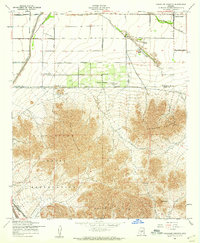
1956 Map of Chandler Heights
USGS Topo · Published 1959About this map
The Gila River Indian Reservation covers the southern half of this mid-century landscape, dominated by the prominent peaks of Santan Mountain, the Goldmine Mountains, and the Malpais Hills. To the north, the transition from high desert to structured agriculture is evident in the grid of irrigation and transport. Chandler Heights stands as a focal point of development, featuring a planned grid of streets like Santan Boulevard and Citrus Heights Road. The map documents the critical role of water management in the arid Pinal and Maricopa County borderlands, noting the Roosevelt Canal and several protective levee structures. Local landmarks such as Rock Peak and The Gap provide navigation points through the desert terrain, while the Southern Pacific railroad and a network of landing strips suggest the era's reliance on diverse transport for this agricultural and mining region.
Find a feature on this map
29 named features on this map. Tap any name to fly to it.
Don’t see what you’re looking for? This feature index may not catch every label — zoom into the map to look around manually.
Map Details
Editions of this 1956 Chandler Heights Map
4 editions found
Other maps of this area

1904 · Desert Well
USGS Topo · 1:62,500

1906 · Desert Well
USGS Topo · 1:62,500

1907 · Sacaton
USGS Topo · 1:62,500

1913 · Mesa
USGS Topo · 1:62,500

1914 · Gila Butte
USGS Topo · 1:62,500

1915 · Mesa
USGS Topo · 1:62,500

1917 · Gila Butte
USGS Topo · 1:62,500

1952 · Gila Butte SE
USGS Topo · 1:24,000

1952 · Chandler
USGS Topo · 1:24,000

1952 · Gila Butte
USGS Topo · 1:24,000