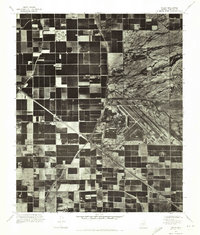
1971 Map of Higley
USGS Topo · Published 1972About this map
Williams Air Force Base dominates the eastern portion of this 1971 orthophotoguad, its runways and complex of hangars and barracks forming a sharp geometric contrast to the surrounding landscape. To the west, the settlement of Higley serves as a focal point amidst an extensive network of rectangular agricultural plots. This aerial survey captures the region just as the irrigation-driven farming economy was reaching its peak before further suburban transformation. The Roosevelt Water Conservation District Canal cuts a distinctive diagonal path across the grid, providing the vital water supply required for these desert fields. Near the northeast corner of the air base, the Desert Proving Grounds mark a specialized site of military or industrial testing, tucked against the more irregular, uncultivated terrain that borders the structured farmlands.
Find a feature on this map
4 named features on this map. Tap any name to fly to it.
Don’t see what you’re looking for? This feature index may not catch every label — zoom into the map to look around manually.
Map Details
Editions of this 1971 Higley Map
This is the sole edition of this map. No revisions or reprints were ever made.
Other maps of this area

1904 · Desert Well
USGS Topo · 1:62,500

1906 · Desert Well
USGS Topo · 1:62,500

1907 · Sacaton
USGS Topo · 1:62,500

1913 · Mesa
USGS Topo · 1:62,500

1914 · Gila Butte
USGS Topo · 1:62,500

1915 · Mesa
USGS Topo · 1:62,500

1917 · Gila Butte
USGS Topo · 1:62,500

1952 · Chandler
USGS Topo · 1:24,000
1952 · Mesa
USGS Topo · 1:24,000

1952 · Gila Butte
USGS Topo · 1:24,000