1980s Maps of Desert Springs, Arizona
Explore 2 historic maps of Desert Springs from the 1980s. These maps offer a rare glimpse into what life looked like during the 1980s — showing old roads, neighborhoods, homes, and landmarks that have changed or disappeared over time.
Whether you're researching your family's past, planning a metal detecting trip, or studying how Desert Springs's landscape evolved across the 1980s, these high-resolution maps are a powerful tool for exploring the history of this region.
- Focus on a specific era: All maps on this page are from the 1980s, giving you a focused view of this time period.
- See what’s changed: Compare century-old streets, trails, and buildings to today's modern landscape using overlays and satellite layers.
- Research with precision: Use these maps for genealogy, historical research, land use analysis, or educational projects.
- View, download, or print: Maps are fully viewable online in high resolution, and can be downloaded or printed for your own records.
Start exploring Desert Springs's history through authentic maps from the 1980s. This is your window into the past.
Desert Springs, AZ maps
(2)- 1985 Map of Littlefield
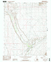 1985 Littlefield1985 Print · USGSThe Virgin River corridor in the 1980s comes to life on this map, documenting the desert settlements of Littlefield and Beaver Dam. Genealogists and researchers can trace local water infrastructure like the Virgin Ditch and natural landmarks including Castle Cliff.2 unique versions available
 - 1987 Map of Littlefield, 1988 Print
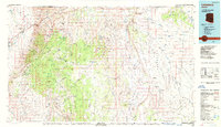 1987 Littlefield1988 Print · USGSNorthwestern Arizona’s high desert comes into focus in the late eighties, showing the remote ranching and mining country along the Utah border. Researchers can trace the path of the Virgin River and locate vital water sites like Wolf Hole Lake, Mormon Well, and the Hidden Mines.2 unique versions available
End of results
Showing maps 1-2 of 2
Top cities near Desert Springs
Frequently asked questions
- What are the different types of historical maps available for Desert Springs?
- What is the oldest map of Desert Springs?
- Where can I purchase historical maps of Desert Springs for my home or office?
- Where can I download high-res historical maps of Desert Springs?
- Are there historical topographic maps available for Desert Springs?
- Is there historical aerial imagery available for Desert Springs?
- Where are historical maps of Desert Springs sourced from?