1985 Map of Littlefield
USGS Topo · Published 1985About this map
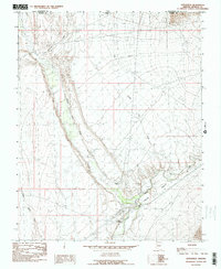
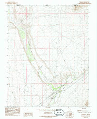
The Virgin Valley of northwest Arizona is the central focus of this 1985 survey, documenting a period of rural development where the Mojave and Washington county lines intersect with the Utah border. The settlements of Littlefield and Beaver Dam anchor the local geography, situated near the confluence of Beaver Dam Wash and the Virgin River. The landscape is defined by its drainage systems, including Welcome Creek, Castle Cliff Wash, and Big Bend Wash, which carve through the arid terrain. The presence of the Virgin Ditch and a Gaging Sta near the river indicates the critical importance of water management for sustaining these desert communities. Significant landmarks such as Castle Cliff and a mapped Corral offer touchpoints for those researching the agricultural and livestock history of this borderlands region.
Find a feature on this map
15 named features on this map. Tap any name to fly to it.
Don’t see what you’re looking for? This feature index may not catch every label — zoom into the map to look around manually.
Map Details
Editions of this 1985 Littlefield Map
2 editions found
Other maps of this area

1885 · St. George
USGS Topo · 1:250,000

1885 · Pioche
USGS Topo · 1:250,000

1886 · Saint Thomas
USGS Topo · 1:250,000

1886 · Mt. Trumbull
USGS Topo · 1:250,000

1886 · Pioche
USGS Topo · 1:250,000

1891 · St. George
USGS Topo · 1:250,000

1892 · Mt. Trumbull
USGS Topo · 1:250,000

1893 · Saint Thomas
USGS Topo · 1:250,000

1953 · Cedar City
USGS Topo · 1:250,000

1953 · Grand Canyon
USGS Topo · 1:250,000