1985 Map of Littlefield
USGS Topo · Published 1985About this map
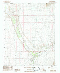
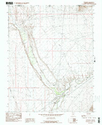
The Virgin River carves a deep path through the Virgin Valley in this mid-1980s look at the northwestern corner of Mohave County. This desert landscape is defined by its watercourses, where the Beaver Dam Wash joins the main river channel near the established settlements of Littlefield and Beaver Dam. The presence of a Gaging Sta and a river-side Campground highlights the importance of the river for both hydrological monitoring and local recreation in this arid environment.
Find a feature on this map
13 named features on this map. Tap any name to fly to it.
Don’t see what you’re looking for? This feature index may not catch every label — zoom into the map to look around manually.
Map Details
Editions of this 1985 Littlefield Map
2 editions found
Other maps of this area

1885 · St. George
USGS Topo · 1:250,000

1885 · Pioche
USGS Topo · 1:250,000

1886 · Saint Thomas
USGS Topo · 1:250,000

1886 · Mt. Trumbull
USGS Topo · 1:250,000

1886 · Pioche
USGS Topo · 1:250,000

1891 · St. George
USGS Topo · 1:250,000

1892 · Mt. Trumbull
USGS Topo · 1:250,000

1893 · Saint Thomas
USGS Topo · 1:250,000

1953 · Cedar City
USGS Topo · 1:250,000

1953 · Grand Canyon
USGS Topo · 1:250,000