1980s Maps of Kingman, Arizona
Explore 2 historic maps of Kingman from the 1980s. These maps offer a rare glimpse into what life looked like during the 1980s — showing old roads, neighborhoods, homes, and landmarks that have changed or disappeared over time.
Whether you're researching your family's past, planning a metal detecting trip, or studying how Kingman's landscape evolved across the 1980s, these high-resolution maps are a powerful tool for exploring the history of this region.
- Focus on a specific era: All maps on this page are from the 1980s, giving you a focused view of this time period.
- See what’s changed: Compare century-old streets, trails, and buildings to today's modern landscape using overlays and satellite layers.
- Research with precision: Use these maps for genealogy, historical research, land use analysis, or educational projects.
- View, download, or print: Maps are fully viewable online in high resolution, and can be downloaded or printed for your own records.
Start exploring Kingman's history through authentic maps from the 1980s. This is your window into the past.
Kingman, AZ maps
(2)- 1982 Map of Davis Dam, 1983 Print
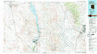 1982 Davis Dam1983 Print · USGSThe Colorado River corridor and the Tri-State area come into focus in the early eighties, showing the growth of Bullhead City and Laughlin near the Davis Dam. Researchers can trace extensive mining operations like the Searchlight Mine or follow the Atchison Topeka and Santa Fe rail line into Kingman.2 unique versions available
 - 1984 Map of Valentine
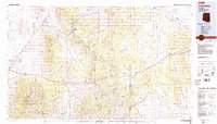 1984 Valentine1984 Print · USGSNorthern Arizona's high desert comes into focus in the mid-1980s as the rail and road network connects remote outposts. Trace the path of the Atchison Topeka and Santa Fe through Valentine and locate mining sites like the Sunshine Mine.2 unique versions available
End of results
Showing maps 1-2 of 2
Top cities near Kingman
- New Kingman-Butler historical maps
- Golden Valley historical maps
- Valle Vista historical maps
- Walnut Creek historical maps
- Lazy Y U historical maps
- So-Hi historical maps
See more
Top neighborhoods of Kingman
Frequently asked questions
- What are the different types of historical maps available for Kingman?
- What is the oldest map of Kingman?
- Where can I purchase historical maps of Kingman for my home or office?
- Where can I download high-res historical maps of Kingman?
- Are there historical topographic maps available for Kingman?
- Is there historical aerial imagery available for Kingman?
- Where are historical maps of Kingman sourced from?