1960s Maps of Kingman, Arizona
Explore 6 historic maps of Kingman from the 1960s. These maps offer a rare glimpse into what life looked like during the 1960s — showing old roads, neighborhoods, homes, and landmarks that have changed or disappeared over time.
Whether you're researching your family's past, planning a metal detecting trip, or studying how Kingman's landscape evolved across the 1960s, these high-resolution maps are a powerful tool for exploring the history of this region.
- Focus on a specific era: All maps on this page are from the 1960s, giving you a focused view of this time period.
- See what’s changed: Compare century-old streets, trails, and buildings to today's modern landscape using overlays and satellite layers.
- Research with precision: Use these maps for genealogy, historical research, land use analysis, or educational projects.
- View, download, or print: Maps are fully viewable online in high resolution, and can be downloaded or printed for your own records.
Start exploring Kingman's history through authentic maps from the 1960s. This is your window into the past.
Kingman, AZ maps
(6)- 1960 Map of Williams
 1960 Williams1960 Print · USGSNorthern Arizona in the mid-twentieth century was defined by its massive canyons and the vital rail line connecting its remote ranches. Genealogists and historians can trace the development of Peach Springs, the high-altitude Bill Williams Mountain, and isolated outposts like Diamond Bar Ranch.
 - 1960 Map of Kingman
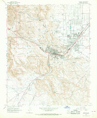
 1960 Kingman1960 Print · USGSThe high desert landscape of the Arizona-Nevada border comes alive in the mid-twentieth century, showcasing the rise of recreation alongside deep-rooted mining history. Genealogists and historians can trace the roots of towns like Kingman and Oatman, or locate remote sites like the Lucky Dutchman Mine and Santa Claus.3 unique versions available
 - 1961 Map of Williams
 1961 Williams1961 Print · USGSNorthern Arizona in the mid-fifties reveals a high-desert landscape of rail towns and deep canyons along the Atchison Topeka and Santa Fe. Researchers can trace old Route 66 through Peach Springs, Seligman, and Ash Fork, or find remote sites like Music Mountain Mine.
 - 1967 Map of Kingman, 1968 Print
 1967 Kingman1968 Print · USGSKingman and the surrounding Mohave County highlands come alive in this late-sixties survey as the town expanded into the Sacramento Valley. Genealogists and historians can trace the development of Hilltop, locate the Mountain View Cem, and follow the Atchison Topeka and Santa Fe RR through McConnico.2 unique versions available
 - 1968 Map of Rattlesnake Hill, 1971 Print
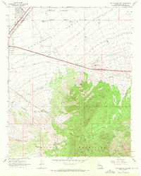 1968 Rattlesnake Hill1971 Print · USGSArizona's high desert meets the mountains in the late 1960s, showing the vital corridors of the Hualapai Valley. Genealogists and historians can locate remote ranch sites like the Lazy Yu Ranch and D-W Ranch alongside the landmark Rattlesnake Hill.3 unique versions available
 - 1968 Map of Stockton Hill, 1971 Print
 1968 Stockton Hill1971 Print · USGSThe Cerbat Mountains north of Kingman appear in the late 1960s as a hub of mining activity and high-desert desert peaks. Genealogists and historians can trace numerous named claims such as the Stockton Mine, C O D Mine, and Western Union Mine.4 unique versions available
End of results
Showing maps 1-6 of 6
Top cities near Kingman
- New Kingman-Butler historical maps
- Golden Valley historical maps
- Valle Vista historical maps
- Walnut Creek historical maps
- Lazy Y U historical maps
- So-Hi historical maps
See more
Top neighborhoods of Kingman
Frequently asked questions
- What are the different types of historical maps available for Kingman?
- What is the oldest map of Kingman?
- Where can I purchase historical maps of Kingman for my home or office?
- Where can I download high-res historical maps of Kingman?
- Are there historical topographic maps available for Kingman?
- Is there historical aerial imagery available for Kingman?
- Where are historical maps of Kingman sourced from?