1970s Maps of Mohave Valley, Arizona
Explore 1 historic maps of Mohave Valley from the 1970s. These maps offer a rare glimpse into what life looked like during the 1970s — showing old roads, neighborhoods, homes, and landmarks that have changed or disappeared over time.
Whether you're researching your family's past, planning a metal detecting trip, or studying how Mohave Valley's landscape evolved across the 1970s, these high-resolution maps are a powerful tool for exploring the history of this region.
- Focus on a specific era: All maps on this page are from the 1970s, giving you a focused view of this time period.
- See what’s changed: Compare century-old streets, trails, and buildings to today's modern landscape using overlays and satellite layers.
- Research with precision: Use these maps for genealogy, historical research, land use analysis, or educational projects.
- View, download, or print: Maps are fully viewable online in high resolution, and can be downloaded or printed for your own records.
Start exploring Mohave Valley's history through authentic maps from the 1970s. This is your window into the past.
Mohave Valley, AZ maps
(1)- 1970 Map of Needles NE, 1973 Print
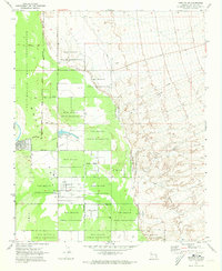 1970 Needles NE1973 Print · USGSThe Fort Mojave Indian Reservation in the early 1970s shows a landscape of developing residential grids set against the desert. Researchers can trace historical routes like the Old Military Jeep Trail or locate the Milltown (Site) and Desert Lawn Cem.
End of results
Showing maps 1-1 of 1
Top cities near Mohave Valley
- Bullhead City historical maps
- Fort Mohave historical maps
- Needles historical maps
- Golden Shores historical maps
- Willow Valley historical maps
- Arizona Village historical maps
See more
Frequently asked questions
- What are the different types of historical maps available for Mohave Valley?
- What is the oldest map of Mohave Valley?
- Where can I purchase historical maps of Mohave Valley for my home or office?
- Where can I download high-res historical maps of Mohave Valley?
- Are there historical topographic maps available for Mohave Valley?
- Is there historical aerial imagery available for Mohave Valley?
- Where are historical maps of Mohave Valley sourced from?