1990s Maps of Aripine, Arizona
Explore 2 historic maps of Aripine from the 1990s. These maps offer a rare glimpse into what life looked like during the 1990s — showing old roads, neighborhoods, homes, and landmarks that have changed or disappeared over time.
Whether you're researching your family's past, planning a metal detecting trip, or studying how Aripine's landscape evolved across the 1990s, these high-resolution maps are a powerful tool for exploring the history of this region.
- Focus on a specific era: All maps on this page are from the 1990s, giving you a focused view of this time period.
- See what’s changed: Compare century-old streets, trails, and buildings to today's modern landscape using overlays and satellite layers.
- Research with precision: Use these maps for genealogy, historical research, land use analysis, or educational projects.
- View, download, or print: Maps are fully viewable online in high resolution, and can be downloaded or printed for your own records.
Start exploring Aripine's history through authentic maps from the 1990s. This is your window into the past.
Aripine, AZ maps
(2)- 1990 Map of Aripine, 1991 Print
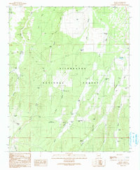 1990 Aripine1991 Print · USGSNavajo County ranching and forest lands are captured in the early 1990s as the high-country landscape of the Sitgreaves National Forest remained largely centered on livestock. Researchers can trace the layout of Aripine, the grounds of Sundown Girls Ranch, and historic water improvements like Shumway Tank and Flake Ranch.
 - 1998 Map of Aripine, 2000 Print
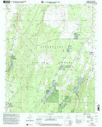 1998 Aripine2000 Print · USGSSettlement in the Navajo County timberlands centered around Aripine during the late nineties, where the forest service and local ranchers managed the rugged terrain. Researchers can locate family outposts like Decker Ranch (Site), Halter Cross Ranch, and the LDS Ranch.
End of results
Showing maps 1-2 of 2
Frequently asked questions
- What are the different types of historical maps available for Aripine?
- What is the oldest map of Aripine?
- Where can I purchase historical maps of Aripine for my home or office?
- Where can I download high-res historical maps of Aripine?
- Are there historical topographic maps available for Aripine?
- Is there historical aerial imagery available for Aripine?
- Where are historical maps of Aripine sourced from?