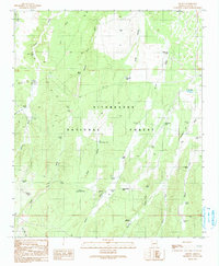
1990 Map of Aripine
USGS Topo · Published 1991About this map
Aripine and the surrounding ranching landscape in Navajo County are the primary focus of this late-twentieth-century study, situated within the bounds of the Sitgreaves National Forest. The map documents a complex system of livestock water management, with numerous named tanks such as Pierce Wash Tank, Horseshoe Tank, and Shumway Tank distributed across the terrain to support local operations like Flake Ranch.
Find a feature on this map
52 named features on this map. Tap any name to fly to it.
Don’t see what you’re looking for? This feature index may not catch every label — zoom into the map to look around manually.
Map Details
Editions of this 1990 Aripine Map
This is the sole edition of this map. No revisions or reprints were ever made.
Other maps of this area

1886 · Holbrook
USGS Topo · 1:250,000

1893 · Holbrook
USGS Topo · 1:250,000

1954 · Holbrook
USGS Topo · 1:250,000

1957 · Holbrook
USGS Topo · 1:250,000

1958 · Holbrook
USGS Topo · 1:250,000

1960 · Holbrook
USGS Topo · 1:250,000

1961 · Clay Springs
USGS Topo · 1:62,500

1961 · Heber
USGS Topo · 1:62,500

1970 · Red Knoll
USGS Topo · 1:24,000
1971 · Zeniff
USGS Topo · 1:24,000