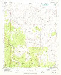
1971 Map of Zeniff
USGS Topo · Published 1973About this map
Sitgreaves National Forest covers much of this high-altitude Arizona landscape, where water management is the defining feature of human settlement. The arid terrain is crisscrossed by numerous named water catchments and livestock tanks, including the Charlie Ross Tank, Little Scott Tank, and Sinkhole Tank, which supported the ranching operations around Zeniff in the early 1970s. These man-made features are vital components of the local economy, scattered throughout a network of seasonal drainages like Pierce Wash and Scott Wash. The map also captures several family-named landmarks such as Purcell Tank and DeSpain Tank, alongside evidence of resource extraction at the Borrow Pit and Gravel Pit. The presence of Dry Lake and a prominent Depression in the north highlights the unique terminal drainage basins of the Colorado Plateau, while the boundaries of T. 14 N. and T. 13 N. provide a clear reference for genealogical and land-use research.
Find a feature on this map
28 named features on this map. Tap any name to fly to it.
Don’t see what you’re looking for? This feature index may not catch every label — zoom into the map to look around manually.
Map Details
Editions of this 1971 Zeniff Map
This is the sole edition of this map. No revisions or reprints were ever made.
Other maps of this area

1886 · Holbrook
USGS Topo · 1:250,000

1893 · Holbrook
USGS Topo · 1:250,000

1954 · Holbrook
USGS Topo · 1:250,000

1957 · Holbrook
USGS Topo · 1:250,000

1958 · Holbrook
USGS Topo · 1:250,000

1960 · Holbrook
USGS Topo · 1:250,000

1961 · Clay Springs
USGS Topo · 1:62,500

1961 · Heber
USGS Topo · 1:62,500

1970 · Red Knoll
USGS Topo · 1:24,000
1971 · Potato Wash NE
USGS Topo · 1:24,000