1990s Maps of Kykotsmovi Village, Arizona
Explore 4 historic maps of Kykotsmovi Village from the 1990s. These maps offer a rare glimpse into what life looked like during the 1990s — showing old roads, neighborhoods, homes, and landmarks that have changed or disappeared over time.
Whether you're researching your family's past, planning a metal detecting trip, or studying how Kykotsmovi Village's landscape evolved across the 1990s, these high-resolution maps are a powerful tool for exploring the history of this region.
- Focus on a specific era: All maps on this page are from the 1990s, giving you a focused view of this time period.
- See what’s changed: Compare century-old streets, trails, and buildings to today's modern landscape using overlays and satellite layers.
- Research with precision: Use these maps for genealogy, historical research, land use analysis, or educational projects.
- View, download, or print: Maps are fully viewable online in high resolution, and can be downloaded or printed for your own records.
Start exploring Kykotsmovi Village's history through authentic maps from the 1990s. This is your window into the past.
Kykotsmovi Village, AZ maps
(4)- 1991 Map of Shungopavi
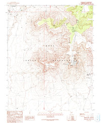 1991 Shungopavi1991 Print · USGSThe high mesas of the Hopi Indian Reservation are documented here in the early nineties, centered on the ancient village of Shungopavi. Genealogists and historians can locate numerous named water sources like Stinkbug Spring and Brownrock Spring used by residents of Second Mesa.
 - 1991 Map of Kykotsmovi
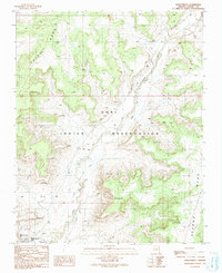 1991 Kykotsmovi1991 Print · USGSThe Hopi heartland on the high mesas of northern Arizona is meticulously documented in this early nineties survey. Genealogists and historians can locate specific villages such as Kykotsmovi and Mungyaovi or trace the levee system along the Oraibi Wash.
 - 1991 Map of Mowa'api
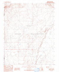 1991 Mowa'api1991 Print · USGSHigh desert terrain within the Hopi Indian Reservation is captured here during the late twentieth century. Researchers can trace land management efforts like the Check Dams along the Oraibi Wash or locate the settlement of Mowa'api.
 - 1991 Map of Hotevilla
 1991 Hotevilla1991 Print · USGSTraditional Hopi villages sit atop high mesas in the early nineties, revealing a landscape of ancient settlements and desert springs. Researchers can trace the layout of Hotevilla, locate the Tug-of-War Historical Marker, and find Hotevilla Spring.
End of results
Showing maps 1-4 of 4
Top cities near Kykotsmovi Village
Top neighborhoods of Kykotsmovi Village
Frequently asked questions
- What are the different types of historical maps available for Kykotsmovi Village?
- What is the oldest map of Kykotsmovi Village?
- Where can I purchase historical maps of Kykotsmovi Village for my home or office?
- Where can I download high-res historical maps of Kykotsmovi Village?
- Are there historical topographic maps available for Kykotsmovi Village?
- Is there historical aerial imagery available for Kykotsmovi Village?
- Where are historical maps of Kykotsmovi Village sourced from?