1980s Maps of Helvetia, Arizona
Explore 1 historic maps of Helvetia from the 1980s. These maps offer a rare glimpse into what life looked like during the 1980s — showing old roads, neighborhoods, homes, and landmarks that have changed or disappeared over time.
Whether you're researching your family's past, planning a metal detecting trip, or studying how Helvetia's landscape evolved across the 1980s, these high-resolution maps are a powerful tool for exploring the history of this region.
- Focus on a specific era: All maps on this page are from the 1980s, giving you a focused view of this time period.
- See what’s changed: Compare century-old streets, trails, and buildings to today's modern landscape using overlays and satellite layers.
- Research with precision: Use these maps for genealogy, historical research, land use analysis, or educational projects.
- View, download, or print: Maps are fully viewable online in high resolution, and can be downloaded or printed for your own records.
Start exploring Helvetia's history through authentic maps from the 1980s. This is your window into the past.
Helvetia, AZ maps
(1)- 1981 Map of Helvetia
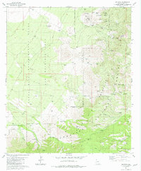 1981 Helvetia1981 Print · USGSThe Santa Rita Mountains of Pima County are shown here in the early 1980s, when the mining heritage of the region was still clearly etched into the landscape. Genealogists and historians can trace the Helvetia townsite and its Helvetia Cem, alongside historic mines like the Tip Top Mine and Morning Star Mine.2 unique versions available
End of results
Showing maps 1-1 of 1
Top cities near Helvetia
- Tucson historical maps
- Sahuarita historical maps
- Vail historical maps
- Corona de Tucson historical maps
- Sonoita historical maps
Frequently asked questions
- What are the different types of historical maps available for Helvetia?
- What is the oldest map of Helvetia?
- Where can I purchase historical maps of Helvetia for my home or office?
- Where can I download high-res historical maps of Helvetia?
- Are there historical topographic maps available for Helvetia?
- Is there historical aerial imagery available for Helvetia?
- Where are historical maps of Helvetia sourced from?