1990s Maps of Hoa Murk, Hickiwan
Explore 2 historic maps of Hoa Murk from the 1990s. These maps offer a rare glimpse into what life looked like during the 1990s — showing old roads, neighborhoods, homes, and landmarks that have changed or disappeared over time.
Whether you're researching your family's past, planning a metal detecting trip, or studying how Hoa Murk's landscape evolved across the 1990s, these high-resolution maps are a powerful tool for exploring the history of this region.
- Focus on a specific era: All maps on this page are from the 1990s, giving you a focused view of this time period.
- See what’s changed: Compare century-old streets, trails, and buildings to today's modern landscape using overlays and satellite layers.
- Research with precision: Use these maps for genealogy, historical research, land use analysis, or educational projects.
- View, download, or print: Maps are fully viewable online in high resolution, and can be downloaded or printed for your own records.
Start exploring Hoa Murk's history through authentic maps from the 1990s. This is your window into the past.
Hoa Murk, Hickiwan maps
(2)- 1990 Map of Sikort Chuapo, 1991 Print
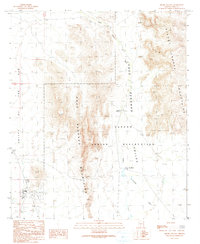 1990 Sikort Chuapo1991 Print · USGSThe Papago Indian Reservation is captured here in the late twentieth century, showing the intersection of traditional landscapes and desert settlement. Local historians can trace the specific layout of Why and locate rural landmarks like a Cem and isolated Prospects in the Pozo Redondo Mountains.
 - 1996 Map of Sikort Chuapo, 2000 Print
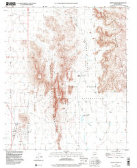 1996 Sikort Chuapo2000 Print · USGSThe Tohono O'odham Reservation landscape in the 1990s centers on the remote crossroads of Why and the peaks of the Pozo Redondo range. Genealogists and desert historians can trace local landmarks like Sikort Chuapo, the Mobile Home Park, and a solitary Grave near the mountains.
End of results
Showing maps 1-2 of 2
Top cities near Hoa Murk
Frequently asked questions
- What are the different types of historical maps available for Hoa Murk?
- What is the oldest map of Hoa Murk?
- Where can I purchase historical maps of Hoa Murk for my home or office?
- Where can I download high-res historical maps of Hoa Murk?
- Are there historical topographic maps available for Hoa Murk?
- Is there historical aerial imagery available for Hoa Murk?
- Where are historical maps of Hoa Murk sourced from?