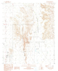
1990 Map of Sikort Chuapo
USGS Topo · Published 1991About this map
Sikort Chuapo and the surrounding desert landscape of the Papago Indian Reservation dominate this Pima County survey. The terrain is defined by the sharp rise of the Pozo Redondo Mountains and the Sikort Chuapo Mountains, which frame the lower-lying Pozo Redondo Valley. Near the western edge of the quadrangle, the small community of Why sits at the junction of two major routes in the Valley of the Ajo, characterized by its distinct residential cluster and a Trailer Park. Small-scale historical activity is evident in several Prospects and isolated landmarks like a Grave and a Cem, which provide specific points of interest for genealogists tracing local presence within the reservation. The ephemeral Sikort Chuapo Wash cuts through the valley floor, marking the drainage pattern of this arid environment during the late twentieth century.
Find a feature on this map
18 named features on this map. Tap any name to fly to it.
Don’t see what you’re looking for? This feature index may not catch every label — zoom into the map to look around manually.
Map Details
Editions of this 1990 Sikort Chuapo Map
This is the sole edition of this map. No revisions or reprints were ever made.
Other maps of this area

1932 · Ajo
USGS Topo · 1:62,500

1934 · Ajo
USGS Topo · 1:62,500

1953 · Ajo
USGS Topo · 1:250,000

1957 · Ajo
USGS Topo · 1:250,000

1958 · Ajo
USGS Topo · 1:250,000

1962 · Ajo
USGS Topo · 1:250,000

1963 · Ajo
USGS Topo · 1:250,000

1963 · Ajo
USGS Topo · 1:62,500

1963 · Sikort Chuapo Mts
USGS Topo · 1:62,500

1963 · Mt. Ajo
USGS Topo · 1:62,500