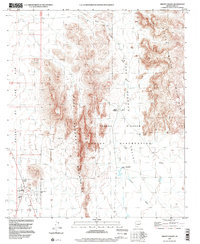
1996 Map of Sikort Chuapo
USGS Topo · Published 2000About this map
The Tohono O'Odham Indian Reservation dominates this desert landscape in the mid-1990s, where the dramatic peaks of the Sikort Chuapo Mountains and Pozo Redondo Mountains rise sharply above the arid floor. In the southwest corner, the uniquely named settlement of Why sits at a crossroads, featuring a Mobile Home Park and basic infrastructure typical of this highway-dependent corridor near the Valley of the Ajo. The map reveals a land defined by water management and transit, from the ephemeral Sikort Chuapo Wash to isolated features like Hoa Murk Water Tank. Human presence is sparse but specific, marked by scattered Prospects for mining and a lone Grave and Cem near the primary settlement of Sikort Chuapo, illustrating the isolation of rural Pima County life at the end of the millennium.
Find a feature on this map
26 named features on this map. Tap any name to fly to it.
Don’t see what you’re looking for? This feature index may not catch every label — zoom into the map to look around manually.
Map Details
Editions of this 1996 Sikort Chuapo Map
This is the sole edition of this map. No revisions or reprints were ever made.
Other maps of this area

1932 · Ajo
USGS Topo · 1:62,500

1934 · Ajo
USGS Topo · 1:62,500

1953 · Ajo
USGS Topo · 1:250,000

1957 · Ajo
USGS Topo · 1:250,000

1958 · Ajo
USGS Topo · 1:250,000

1962 · Ajo
USGS Topo · 1:250,000

1963 · Ajo
USGS Topo · 1:250,000

1963 · Ajo
USGS Topo · 1:62,500

1963 · Sikort Chuapo Mts
USGS Topo · 1:62,500

1963 · Mt. Ajo
USGS Topo · 1:62,500