1940s Maps of Topawa, Arizona
Explore 10 historic maps of Topawa from the 1940s. These maps offer a rare glimpse into what life looked like during the 1940s — showing old roads, neighborhoods, homes, and landmarks that have changed or disappeared over time.
Whether you're researching your family's past, planning a metal detecting trip, or studying how Topawa's landscape evolved across the 1940s, these high-resolution maps are a powerful tool for exploring the history of this region.
- Focus on a specific era: All maps on this page are from the 1940s, giving you a focused view of this time period.
- See what’s changed: Compare century-old streets, trails, and buildings to today's modern landscape using overlays and satellite layers.
- Research with precision: Use these maps for genealogy, historical research, land use analysis, or educational projects.
- View, download, or print: Maps are fully viewable online in high resolution, and can be downloaded or printed for your own records.
Start exploring Topawa's history through authentic maps from the 1940s. This is your window into the past.
Topawa, AZ maps
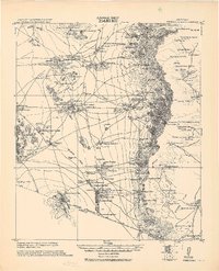
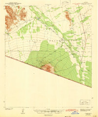
(10)- 1941 Map of Presumido Peak
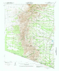 1941 Presumido Peak1941 Print · USGSThe Arizona borderlands in the early 1940s are defined here by cattle ranching and tribal lands along the international line. Researchers can trace historic properties like Rancho de la Osa and Buenos Aires Ranch or locate the Site of Old Indian Fort near Sasabe.2 unique versions available
 - 1941 Map of Baboquivari Peak, 1955 Print
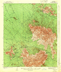
 1941 Baboquivari Peak1955 Print · USGSArizona's Tohono O'odham lands come alive in this wartime survey, showing the deep connection between ranching families and the desert landscape. Genealogists and historians can trace the locations of the Allison Mine, Fresnal Canyon School, and numerous holdings like Otero Ranch.3 unique versions available
 - 1941 Map of Vamori, 1958 Print
 1941 Vamori1958 Print · USGSTraditional O'odham life in the early 1940s is mapped here across the desert expanses of the Papago Indian Reservation. Genealogists and historians can locate remote settlements and family landmarks including San Miguel, Ak Chut Vaya, and San Agustin Ranch.3 unique versions available
 - 1941 Map of Sells, 1969 Print
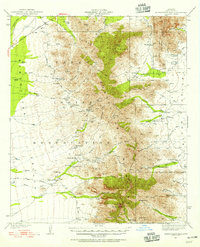
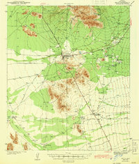
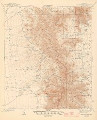
 1941 Sells1969 Print · USGSThe Papago Indian Reservation in the early 1940s reveals a desert landscape of ancestral villages and active mining. Trace family roots and desert trails through Sells, Topawa, and the historic San Solano Mission.
 - 1942 Map of Comobabi
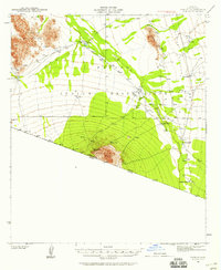
 1942 Comobabi1942 Print · USGSThe Papago Indian Reservation comes into focus during the late 1930s, showing a network of remote desert settlements and scattered mountain mines. Genealogists and historians can trace the foundations of Sil Nakya, Ko Vaya, and mining sites like the Picacho Mine.2 unique versions available
 - 1943 Map of Sells
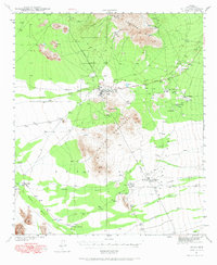
 1943 Sells1943 Print · USGSThe Papago Indian Reservation in the early 1940s reveals a desert landscape of traditional settlements and active mining. Genealogists and historians can trace family roots through the San Solano Mission, Topawa P O, and villages like Artesa or Ali Chuk Son.4 unique versions available
 - 1943 Map of Fresnal
 1943 Fresnal1943 Print · USGSSouthern Arizona’s borderlands and tribal territories are captured here in the 1940s, shortly after the height of early mining efforts. Researchers can trace ancestral connections in villages like Indian Oasis or locate vanished industrial sites like the Golden Age Mine & Mill.
 - 1943 Map of Presumido Peak
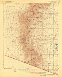 1943 Presumido Peak1943 Print · USGSSouthern Arizona’s borderlands are mapped here in the early 1940s, showing the high ranching country and tribal lands of Pima County. Researchers can trace historic family holdings like Rancho de la Osa and Santa Margarita Ranch or locate the Site of Old Indian Fort.2 unique versions available
 - 1943 Map of Vamori
 1943 Vamori1943 Print · USGSThe Papago Indian Reservation and the international border define this high-desert region during the early 1940s. Genealogists and historians can trace indigenous settlements and ranching outposts like Vamori, San Miguel, and the San Agustin Ranch.2 unique versions available
 - 1944 Map of Baboquivari Peak
 1944 Baboquivari Peak1944 Print · USGSThe Papago Indian Reservation in the early 1940s reveals a landscape of isolated ranches and tribal settlements. Genealogists can trace family holdings like Otero Ranch or locate the Fresnal Canyon Sch and the Allison Mine near the base of Baboquivari Peak.2 unique versions available
End of results
Showing maps 1-10 of 10
Top cities near Topawa
Top neighborhoods of Topawa
- Chukson historical maps
- Topawa historical maps
- Choulic historical maps
- Kahachi Miliuk historical maps
- Pitoikam historical maps
- Vopolo Havoka historical maps
See more
Frequently asked questions
- What are the different types of historical maps available for Topawa?
- What is the oldest map of Topawa?
- Where can I purchase historical maps of Topawa for my home or office?
- Where can I download high-res historical maps of Topawa?
- Are there historical topographic maps available for Topawa?
- Is there historical aerial imagery available for Topawa?
- Where are historical maps of Topawa sourced from?