1940s Maps of Maricopa, Arizona
Explore 2 historic maps of Maricopa from the 1940s. These maps offer a rare glimpse into what life looked like during the 1940s — showing old roads, neighborhoods, homes, and landmarks that have changed or disappeared over time.
Whether you're researching your family's past, planning a metal detecting trip, or studying how Maricopa's landscape evolved across the 1940s, these high-resolution maps are a powerful tool for exploring the history of this region.
- Focus on a specific era: All maps on this page are from the 1940s, giving you a focused view of this time period.
- See what’s changed: Compare century-old streets, trails, and buildings to today's modern landscape using overlays and satellite layers.
- Research with precision: Use these maps for genealogy, historical research, land use analysis, or educational projects.
- View, download, or print: Maps are fully viewable online in high resolution, and can be downloaded or printed for your own records.
Start exploring Maricopa's history through authentic maps from the 1940s. This is your window into the past.
Maricopa, AZ maps
(2)- 1946 Map of Antelope Peak, 1955 Print
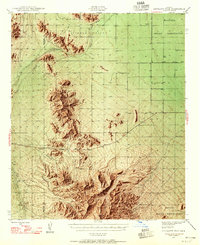 1946 Antelope Peak1955 Print · USGSThe high desert of Pinal County in the late 1940s is captured here, showing the intersection of tribal lands and the open basin. Researchers can trace early routes like Route 84 past prominent landmarks like Antelope Peak, Table Top, and the watering holes of Hidden Valley.3 unique versions available
 - 1948 Map of Antelope Peak
 1948 Antelope Peak1948 Print · USGSThe high desert south of Phoenix comes alive in the late 1940s, showing the dramatic rise of Antelope Peak and Table Top above the valley floor. Researchers can trace the early borders of the Maricopa Indian Reservation and locate isolated desert Well sites and the winding Vekol Wash.2 unique versions available
End of results
Showing maps 1-2 of 2
Top cities near Maricopa
Top neighborhoods of Maricopa
- Heaton historical maps
- Sorrento historical maps
- Rancho El Dorado historical maps
- Cobblestone historical maps
- Santa Rosa Crossings historical maps
- Lakes at Rancho El Dorado historical maps
See more
Frequently asked questions
- What are the different types of historical maps available for Maricopa?
- What is the oldest map of Maricopa?
- Where can I purchase historical maps of Maricopa for my home or office?
- Where can I download high-res historical maps of Maricopa?
- Are there historical topographic maps available for Maricopa?
- Is there historical aerial imagery available for Maricopa?
- Where are historical maps of Maricopa sourced from?