1980s Maps of Maricopa, Arizona
Explore 4 historic maps of Maricopa from the 1980s. These maps offer a rare glimpse into what life looked like during the 1980s — showing old roads, neighborhoods, homes, and landmarks that have changed or disappeared over time.
Whether you're researching your family's past, planning a metal detecting trip, or studying how Maricopa's landscape evolved across the 1980s, these high-resolution maps are a powerful tool for exploring the history of this region.
- Focus on a specific era: All maps on this page are from the 1980s, giving you a focused view of this time period.
- See what’s changed: Compare century-old streets, trails, and buildings to today's modern landscape using overlays and satellite layers.
- Research with precision: Use these maps for genealogy, historical research, land use analysis, or educational projects.
- View, download, or print: Maps are fully viewable online in high resolution, and can be downloaded or printed for your own records.
Start exploring Maricopa's history through authentic maps from the 1980s. This is your window into the past.
Maricopa, AZ maps
(4)- 1981 Map of Phoenix South
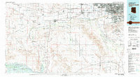 1981 Phoenix South1981 Print · USGSThe desert south of Phoenix in the early eighties shows a unique mix of tribal lands, military outposts, and agricultural growth. Genealogists and historians can trace settlements like Ak Chin and Valencia or locate the Buckeye Copper Mine and Luke Aux Field No 6.2 unique versions available
 - 1981 Map of Antelope Peak NE, 1982 Print
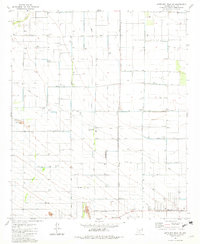 1981 Antelope Peak NE1982 Print · USGSAgricultural development and industrial infrastructure dominate this Pinal County landscape in the early eighties. Researchers can trace the layout of the Ak-Chin Indian Reservation and locate local landmarks like the Casa Grande Turbine Station and Peters Corner.2 unique versions available
 - 1981 Map of Gila Bend, 1996 Print
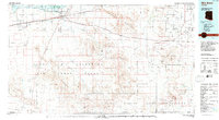 1981 Gila Bend1996 Print · USGSSouthern Arizona in the early eighties reveals a vast desert corridor shaped by military ranges, indigenous lands, and historical mining. Genealogists and historians can trace rail-side settlements like Theba and Piedra or locate the historic Vekol Mine and Reward Mine.
 - 1982 Map of Ajo
 1982 Ajo1982 Print · USGSThe Arizona-Sonora borderlands come into focus in the early eighties, showcasing a landscape of desert mining towns and expansive tribal lands. Trace the Southern Pacific rail line through Gila Bend or explore the remote settlements of Ajo and Lukeville.
End of results
Showing maps 1-4 of 4
Top cities near Maricopa
Top neighborhoods of Maricopa
- Heaton historical maps
- Sorrento historical maps
- Rancho El Dorado historical maps
- Cobblestone historical maps
- Santa Rosa Crossings historical maps
- Lakes at Rancho El Dorado historical maps
See more
Frequently asked questions
- What are the different types of historical maps available for Maricopa?
- What is the oldest map of Maricopa?
- Where can I purchase historical maps of Maricopa for my home or office?
- Where can I download high-res historical maps of Maricopa?
- Are there historical topographic maps available for Maricopa?
- Is there historical aerial imagery available for Maricopa?
- Where are historical maps of Maricopa sourced from?