1970s Maps of Maricopa, Arizona
Explore 6 historic maps of Maricopa from the 1970s. These maps offer a rare glimpse into what life looked like during the 1970s — showing old roads, neighborhoods, homes, and landmarks that have changed or disappeared over time.
Whether you're researching your family's past, planning a metal detecting trip, or studying how Maricopa's landscape evolved across the 1970s, these high-resolution maps are a powerful tool for exploring the history of this region.
- Focus on a specific era: All maps on this page are from the 1970s, giving you a focused view of this time period.
- See what’s changed: Compare century-old streets, trails, and buildings to today's modern landscape using overlays and satellite layers.
- Research with precision: Use these maps for genealogy, historical research, land use analysis, or educational projects.
- View, download, or print: Maps are fully viewable online in high resolution, and can be downloaded or printed for your own records.
Start exploring Maricopa's history through authentic maps from the 1970s. This is your window into the past.
Maricopa, AZ maps
(6)- 1971 Map of Phoenix
 1971 Phoenix1971 Print · USGSCentral Arizona at the start of the seventies shows a desert metropolis expanding toward the Sun Valley retirement boom. Trace the growth of Sun City and Glendale, or locate remote historic sites like the Vulture Gold Mine and Nottbusch Cemetery.
 - 1971 Map of Maricopa, 1972 Print
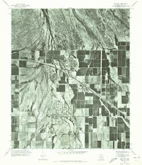 1971 Maricopa1972 Print · USGSMaricopa and the surrounding Pinal County desert are shown as they appeared in the early seventies, dominated by an expanding grid of agricultural development. Researchers can trace the layout of the Ak Chin community and the natural path of Vekol Wash.
 - 1971 Map of Antelope Peak NE, 1972 Print
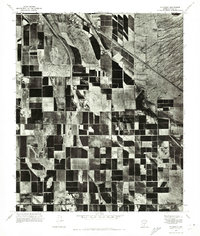
 1971 Antelope Peak NE1972 Print · USGSPinal County agriculture is captured at its early 1970s height in this detailed orthophotoquad survey. Researchers can trace the geometric field patterns and the natural course of Vekol Wash as it existed decades ago.
 - 1971 Map of Sacaton Butte, 1972 Print
 1971 Sacaton Butte1972 Print · USGSPinal County agriculture and desert landscapes are frozen in time during the early seventies in this aerial survey. Genealogists and local historians can pinpoint the layout of Casa Blanca and the terrain surrounding Sacaton Butte as they appeared decades ago.
 - 1971 Map of Enid, 1972 Print
 1971 Enid1972 Print · USGSThe arid landscape near Enid is captured in the early seventies, showing the sharp line between desert drainage and irrigated fields. Genealogists and researchers can trace the rail corridor and the scattered structures of Palo Verde.
 - 1971 Map of Stanfield, 1972 Print
 1971 Stanfield1972 Print · USGSThe agricultural landscape of Pinal County is captured in the early seventies, showing a highly developed grid of desert farm plots. Local historians can trace the early footprint of Stanfield and the natural course of the Santa Cruz Wash across the terrain.
End of results
Showing maps 1-6 of 6
Top cities near Maricopa
Top neighborhoods of Maricopa
- Heaton historical maps
- Sorrento historical maps
- Rancho El Dorado historical maps
- Cobblestone historical maps
- Santa Rosa Crossings historical maps
- Lakes at Rancho El Dorado historical maps
See more
Frequently asked questions
- What are the different types of historical maps available for Maricopa?
- What is the oldest map of Maricopa?
- Where can I purchase historical maps of Maricopa for my home or office?
- Where can I download high-res historical maps of Maricopa?
- Are there historical topographic maps available for Maricopa?
- Is there historical aerial imagery available for Maricopa?
- Where are historical maps of Maricopa sourced from?