Old Maps of Oro Blanco, Arizona for Genealogy
Trace your family roots with 14 historic maps of Oro Blanco. These high-res maps reveal old neighborhoods, homesites, landmarks, and streets — helping you uncover where your ancestors lived and how the area evolved over time.
- Explore historic neighborhoods: Identify where your relatives may have lived in the 1800s or 1900s.
- Compare maps over time: Trace the changes in streets, buildings, and landmarks for multi-generational research.
- Perfect for genealogy & ancestry research: Used by family historians and researchers to map out lineage and migration.
These maps are an incredible resource for exploring your personal connection to Oro Blanco's past.
Oro Blanco, AZ maps
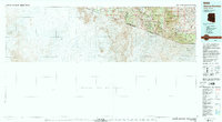
(14)- 1921 Map of Old Glory
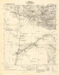 1921 Old Glory1921 Print · USGSThe Arizona borderlands appear as a network of cattle ranches and mining outposts in this early twentieth-century military reconnaissance. Genealogists and historians can trace family operations like Lopez, Alamito Ranch, and the Old Glory Mine.2 unique versions available
 - 1942 Map of Oro Blanco, 1961 Print
 1942 Oro Blanco1961 Print · USGSThe Arizona-Mexico borderlands come to life in this early 1940s survey of Santa Cruz County. Genealogists and historians can trace the legacy of the local mining boom through sites like Oro Blanco and the Old Glory Mine, alongside working spreads such as Garcia Ranch.3 unique versions available
 - 1943 Map of Old Glory
 1943 Old Glory1943 Print · USGSThe Arizona-Mexico borderlands come into focus in this mid-century reconnaissance, capturing the mining and ranching life of the high desert. Researchers can trace the locations of Old Glory Mine, Ruby P.O. (Montana), and historic outposts like Tres Bellotas.
 - 1944 Map of Oro Blanco
 1944 Oro Blanco1944 Print · USGSThe Arizona-Mexico borderlands are captured here in the early 1940s, highlighting a landscape transition from active mining to remote ranching. Genealogists and historians can locate old claims like the Yellow Jacket Mine and family sites like Garcia Ranch.2 unique versions available
 - 1956 Map of Nogales, 1963 Print
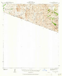
 1956 Nogales1963 Print · USGSSouthern Arizona in the mid-fifties is captured here from the Papago tribal lands to the San Pedro valley. Genealogists and historians can trace border settlements like Sasabe, the legacy of Tombstone, and old mining sites including the Mary G Mine.4 unique versions available
 - 1958 Map of Nogales
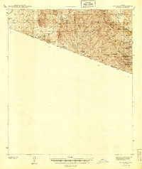
 1958 Nogales1958 Print · USGSSouthern Arizona in the late fifties was a landscape of international borders and high-desert outposts, dominated by the Huachuca Mountains and the Papago Indian Reservation. Local historians can trace old mining camps like Ruby and Greaterville or locate historic military grounds at the Fort Huachuca Military Reservation.
 - 1959 Map of Nogales
 1959 Nogales1959 Print · USGSThe Southern Arizona borderlands appear in the late fifties as a complex landscape of military ranges, tribal lands, and high-desert mining towns. Local historians can trace the Southern Pacific rail lines connecting Tombstone and Benson or locate family ranches such as Canoa Ranch.
 - 1979 Map of Bartlett Mtn
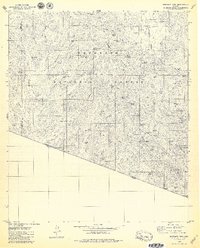 1979 Bartlett Mtn1979 Print · USGSThe Arizona-Mexico borderlands come into focus in the late seventies, showing a landscape defined by ranching and a legacy of mining. Trace remote operations like the Yellow Jacket Mine, find the El Oro Cemetery, and locate the Old Mill Site near Warsaw Canyon.4 unique versions available
 - 1994 Map of Atascosa Mountains
 1994 Atascosa Mountains1994 Print · USGSThe Arizona-Sonora borderlands come into focus in this mid-nineties survey of the Santa Cruz County high desert. Researchers can trace the remote outpost of Sasabe and the mining history near Oro Blanco or the Morning Star Mine.2 unique versions available
 - 2004 Map of Bartlett Mountain, 2007 Print
 2004 Bartlett Mountain2007 Print · USGSArizona's southern borderlands come into focus in the early 2000s as a region of deep canyons and historic mining claims. Trace the legacy of extraction at the Saint Christopher Mine, locate the El Oro Cem, or find the Casa Piedra ruins near the international line.
 - 2012 Map of Bartlett Mountain, 2012 Print
 2012 Bartlett Mountain2012 Print · USGSCovers Oro Blanco, including Old Glory, La Tinaja, and other nearby areas
 - 2014 Map of Bartlett Mountain, 2014 Print
 2014 Bartlett Mountain2014 Print · USGSCovers Oro Blanco, including Old Glory, La Tinaja, and other nearby areas
 - 2018 Map of Bartlett Mountain, 2018 Print
 2018 Bartlett Mountain2018 Print · USGSCovers Oro Blanco, including Old Glory, La Tinaja, and other nearby areas
 - 2021 Map of Bartlett Mountain, 2021 Print
 2021 Bartlett Mountain2021 Print · USGSThe Arizona borderlands near the Santa Cruz and Pima county lines are captured here in the early twenty-first century. Genealogists and historians can trace the remote outposts of Oro Blanco and Old Glory or locate landmarks like Cemetery Tank.
End of results
Showing maps 1-14 of 14
Top cities near Oro Blanco
Frequently asked questions
- What are the different types of historical maps available for Oro Blanco?
- What is the oldest map of Oro Blanco?
- Where can I purchase historical maps of Oro Blanco for my home or office?
- Where can I download high-res historical maps of Oro Blanco?
- Are there historical topographic maps available for Oro Blanco?
- Is there historical aerial imagery available for Oro Blanco?
- Where are historical maps of Oro Blanco sourced from?