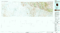
1994 Map of Atascosa Mountains
USGS Topo · Published 1994About this map
Oro Blanco and the surrounding high desert canyonlands define the border country of Santa Cruz and Pima counties during the mid-1990s. This survey illustrates the complex intersection of the United States of America Estados Unidos Mexicanos boundary as it cuts through the Atascosa Mountains and Pajarito Mountains. The landscape is a mix of protected lands and mining history, with the Morning Star Mine situated among rugged summits like Atascosa Peak and Montana Peak.
Find a feature on this map
33 named features on this map. Tap any name to fly to it.
Don’t see what you’re looking for? This feature index may not catch every label — zoom into the map to look around manually.
Map Details
Editions of this 1994 Atascosa Mountains Map
2 editions found
Other maps of this area

1904 · Patagonia
USGS Topo · 1:125,000

1905 · Patagonia
USGS Topo · 1:125,000

1905 · Nogales
USGS Topo · 1:125,000

1920 · Arivaca
USGS Topo · 1:125,000

1921 · Old Glory
USGS Topo · 1:125,000

1922 · Agus Caliente
USGS Topo · 1:62,500

1933 · Calabasas
USGS Topo · 1:62,500

1939 · Tubac
USGS Topo · 1:62,500

1941 · Presumido Peak
USGS Topo · 1:62,500

1941 · Arivaca
USGS Topo · 1:62,500