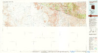
1994 Map of Atascosa Mountains
USGS Topo · Published 1994About this map
The United States-Mexico border defines the southern reach of this landscape, where the Atascosa Mountains and Pajarito Mountains rise above the high desert. Settlement is concentrated in small outposts like Sasabe, home to a U.S. Customs station, and Arivaca, which serves as a gateway to the Buenos Aires National Wildlife Refuge. The map details a region shaped by historic mineral extraction, evidenced by the Montana Mine, Warsaw Mine, and Yellow Jacket Mine scattered near Oro Blanco. High-altitude landmarks such as Atascosa Peak, Castle Rock, and Montana Peak overlook deep drainages like Peck Canyon and Bear Valley. This survey captures the transition from protected wilderness areas like the Pajarito Mountain Wilderness to the open ranching and mining lands that have long characterized the Santa Cruz County borderlands.
Find a feature on this map
34 named features on this map. Tap any name to fly to it.
Don’t see what you’re looking for? This feature index may not catch every label — zoom into the map to look around manually.
Map Details
Editions of this 1994 Atascosa Mountains Map
2 editions found
Other maps of this area

1904 · Patagonia
USGS Topo · 1:125,000

1905 · Patagonia
USGS Topo · 1:125,000

1905 · Nogales
USGS Topo · 1:125,000

1920 · Arivaca
USGS Topo · 1:125,000

1921 · Old Glory
USGS Topo · 1:125,000

1922 · Agus Caliente
USGS Topo · 1:62,500

1933 · Calabasas
USGS Topo · 1:62,500

1939 · Tubac
USGS Topo · 1:62,500

1941 · Presumido Peak
USGS Topo · 1:62,500

1941 · Arivaca
USGS Topo · 1:62,500