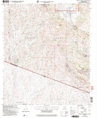
2004 Map of Bartlett Mountain
USGS Topo · Published 2007About this map
Cobre Ridge and Bartlett Mountain define this borderland geography, where the southern edge of the Coronado National Forest meets the international boundary between the United States and Mexico. This 2004 revision reveals a landscape shaped by mineral extraction and ranching, with numerous shafts and prospects such as the Saint Christopher Mine and Yellow Jacket Mine dotting the northern slopes. The map traces the rugged interface of Pima and Santa Cruz counties, highlighting historic outposts like Oro Blanco Ranch and the Immigration Station at the border. Cultural sites, including the El Oro Cem and the Casa Piedra ruins, offer physical touchpoints for genealogists and local historians studying the mining camps and homesteads that once anchored this arid canyon country near the Arizona and Sonora line.
Find a feature on this map
95 named features on this map. Tap any name to fly to it.
Don’t see what you’re looking for? This feature index may not catch every label — zoom into the map to look around manually.
Map Details
Editions of this 2004 Bartlett Mountain Map
This is the sole edition of this map. No revisions or reprints were ever made.
Other maps of this area

1920 · Arivaca
USGS Topo · 1:125,000

1921 · Old Glory
USGS Topo · 1:125,000

1939 · Tubac
USGS Topo · 1:62,500

1941 · Arivaca
USGS Topo · 1:62,500

1942 · Ruby
USGS Topo · 1:62,500

1942 · Oro Blanco
USGS Topo · 1:62,500

1943 · Arivaca
USGS Topo · 1:62,500

1943 · Old Glory
USGS Topo · 1:125,000

1943 · Tubac
USGS Topo · 1:62,500

1944 · Oro Blanco
USGS Topo · 1:62,500