1940s Maps of Cordes, Arizona
Explore 3 historic maps of Cordes from the 1940s. These maps offer a rare glimpse into what life looked like during the 1940s — showing old roads, neighborhoods, homes, and landmarks that have changed or disappeared over time.
Whether you're researching your family's past, planning a metal detecting trip, or studying how Cordes's landscape evolved across the 1940s, these high-resolution maps are a powerful tool for exploring the history of this region.
- Focus on a specific era: All maps on this page are from the 1940s, giving you a focused view of this time period.
- See what’s changed: Compare century-old streets, trails, and buildings to today's modern landscape using overlays and satellite layers.
- Research with precision: Use these maps for genealogy, historical research, land use analysis, or educational projects.
- View, download, or print: Maps are fully viewable online in high resolution, and can be downloaded or printed for your own records.
Start exploring Cordes's history through authentic maps from the 1940s. This is your window into the past.
Cordes, AZ maps
(3)- 1947 Map of Mayer, 1955 Print
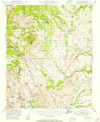 1947 Mayer1955 Print · USGSYavapai County mining and ranching cultures are captured here just after the war, showing the network of claims and homesteads within the Prescott National Forest. Researchers can trace old operations like the Stoddard Mine and family holdings such as the Burmister Ranch.2 unique versions available
 - 1948 Map of Mayer
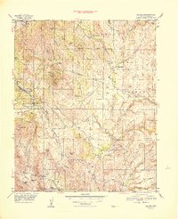 1948 Mayer1948 Print · USGSArizona's mining and ranching frontier is well established in Yavapai County during the late 1940s. Researchers can trace the industrial footprint of the Blue Bell Mine and Golden Turkey Mine or locate early family holdings like Burmister Ranch.
 - 1949 Map of Mayer
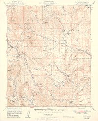 1949 Mayer1949 Print · USGSThe mining and ranching culture of Yavapai County is captured here in the late 1940s. Genealogists and researchers can trace the A T & S F rail line through Mayer to historic sites like the Blue Bell Mine and St Johns Mine.2 unique versions available
End of results
Showing maps 1-3 of 3
Top cities near Cordes
- Prescott historical maps
- Prescott Valley historical maps
- Camp Verde historical maps
- Dewey-Humboldt historical maps
- Cordes Lakes historical maps
- Spring Valley historical maps
Frequently asked questions
- What are the different types of historical maps available for Cordes?
- What is the oldest map of Cordes?
- Where can I purchase historical maps of Cordes for my home or office?
- Where can I download high-res historical maps of Cordes?
- Are there historical topographic maps available for Cordes?
- Is there historical aerial imagery available for Cordes?
- Where are historical maps of Cordes sourced from?