1970s Maps of Prescott Valley, Arizona
Explore 6 historic maps of Prescott Valley from the 1970s. These maps offer a rare glimpse into what life looked like during the 1970s — showing old roads, neighborhoods, homes, and landmarks that have changed or disappeared over time.
Whether you're researching your family's past, planning a metal detecting trip, or studying how Prescott Valley's landscape evolved across the 1970s, these high-resolution maps are a powerful tool for exploring the history of this region.
- Focus on a specific era: All maps on this page are from the 1970s, giving you a focused view of this time period.
- See what’s changed: Compare century-old streets, trails, and buildings to today's modern landscape using overlays and satellite layers.
- Research with precision: Use these maps for genealogy, historical research, land use analysis, or educational projects.
- View, download, or print: Maps are fully viewable online in high resolution, and can be downloaded or printed for your own records.
Start exploring Prescott Valley's history through authentic maps from the 1970s. This is your window into the past.
Prescott Valley, AZ maps
(6)- 1973 Map of Prescott Valley North, 1976 Print
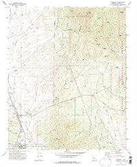
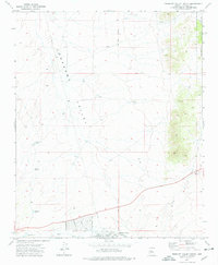 1973 Prescott Valley North1976 Print · USGSIn the early 1970s, the area north of Prescott Valley was a landscape of ranching water tanks and early residential street grids. Trace the beginnings of local neighborhoods and find historical sites like the Old Hopkins Mine and the Agua Fria River.3 unique versions available
 - 1973 Map of Hickey Mountain, 1977 Print
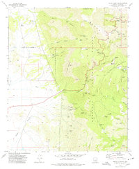 1973 Hickey Mountain1977 Print · USGSArizona's Black Hills come alive in the 1970s, showing the intersection of Prescott National Forest recreation and deep-rooted mining history. Trace the trails of early prospectors and ranchers at the Yaeger Mine, Mingus Springs Ranch, and the Jerome Grande Shaft.3 unique versions available
 - 1973 Map of Prescott Valley South, 1977 Print
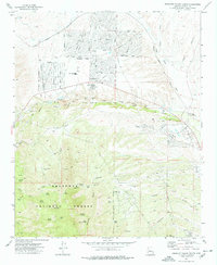 1973 Prescott Valley South1977 Print · USGSPrescott Valley was transitioning from its ranching roots to suburban development in the early 1970s. Trace this growth alongside historic mining sites like Doodlebug Diggings and the Iron King Mine, or locate family landmarks like Lake Valley Sch.2 unique versions available
 - 1973 Map of Chino Valley South, 1977 Print
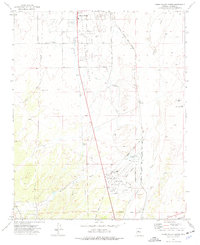 1973 Chino Valley South1977 Print · USGSYavapai County during the early 1970s shows a landscape of aviation and irrigation development south of the town center. Local researchers can trace the Atchison Topeka and Santa Fe rail line, Rolling Hills Cem, and private airstrips like Robin Landing Field.2 unique versions available
 - 1973 Map of Humboldt, 1977 Print
 1973 Humboldt1977 Print · USGSThe Agua Fria River valley in the early seventies shows a landscape defined by the mining industry and the Atchison Topeka and Santa Fe railroad. Researchers can trace family history at Henderson Cem or explore mineral history at the Shylock Mine and Ambassador Mine.
 - 1973 Map of Prescott, 1977 Print
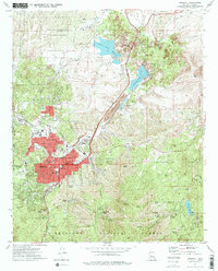 1973 Prescott1977 Print · USGSPrescott at the start of the seventies shows a growing mountain city balanced against its storied military and institutional history. Researchers can trace the layout of the Whipple Barracks Military Reservation, the Yavapai Indian Reservation, and local sites like the Odd Fellows Cemetery.2 unique versions available
End of results
Showing maps 1-6 of 6
Top cities near Prescott Valley
- Prescott historical maps
- Dewey-Humboldt historical maps
- Clarkdale historical maps
- Jerome historical maps
- Chino Valley historical maps
Top neighborhoods of Prescott Valley
Frequently asked questions
- What are the different types of historical maps available for Prescott Valley?
- What is the oldest map of Prescott Valley?
- Where can I purchase historical maps of Prescott Valley for my home or office?
- Where can I download high-res historical maps of Prescott Valley?
- Are there historical topographic maps available for Prescott Valley?
- Is there historical aerial imagery available for Prescott Valley?
- Where are historical maps of Prescott Valley sourced from?